Thursday 28 March 2013

Lamp Posts to Addresses: gold dust in the attributes

Local Government Open Data 4


I'm so used to a lot of open data being poorly attributed that I did not look at the Nottingham street light data until I'd imported it into PostGIS. Apart from lacking the asset identifier, and having redundant fields for the x and y positions of the geometry, it has two fields of fantastic value for enhancing OpenStreetMap.

Lenton Sands addresses
Lenton Sands area of Nottingham showing House Numbers from Lamp Post data overlaid on OSM


Tuesday 26 March 2013

Street Lights: Local Government Open Data 3

Another data set released by my local council contains the locations of all the street lights owned (or operated) by the council. Now I have no intention (or any desire) to import this data into OpenStreetMap. Is it any use in the open data context?

There are two obvious questions that can be asked using street light data:
  • How well mapped are all public highways (i.e., including footways and cycleways) in the city?
  • Are the highways on OSM accurately mapped?
Street lights are spaced at specific intervals according to the type of highway, it's width and the nature of the light source. This means that their accurate placement is determined by the council beforehand, all location data is to the nearest metre. Since most lights are situated immediately adjacent to the road carriageway they will be a short distance from the road centre line (say under 10 metres).

It is trivial to buffer the network of highways from OSM (via a Geofabrik download) and then use geometry operators to find all lights within the highway buffer envelope, and all outside the envelope. Using a very simple constant buffer of 10 metres I obtained the following result:

Nottingham Street Lights cf. OSM Highways
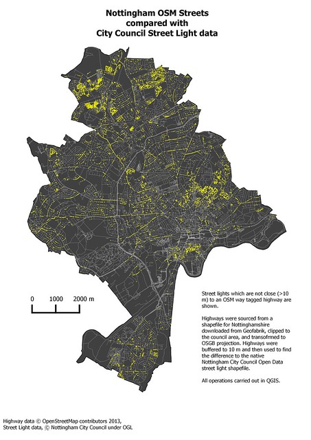
Street lights which are not close to OSM roads (best viewed large).


Saturday 16 March 2013

Local Government Open Data 2: Checking for Completeness

My second look at Nottingham City Council's open data, is a very recent release : "Licensed Premises". I've also changed the title of the post as I believe that the topic, issues and conclusions I draw are relevant to  sources of local open data anywhere.

SK5739 : Ye Olde Trip to Jerusalem -  Nottingham by Richard Hoare
Ye Olde Trip to Jerusalem - Nottingham
  © Copyright Richard Hoare and licensed for reuse under this Creative Commons Licence.

I'd hoped that this would be solely concerned with the sale of alcohol as this would enable a good cross-check against mapping of pubs, bars and restaurants. However,as well as licenses for sale of alcohol on and off the premises, it includes categories for licensing of musical performances, boxing, wrestling. late-night sales and several other things.


Tuesday 12 March 2013

Nottingham Open Data 1 : CCTV Cameras

It's amazing how much difference a couple of years makes in the availability of data under open licenses. My local council, Nottingham City Council, now has at least 40 different data sets available, and more are appearing all the time.

Of course not all of them are useful for improving OpenStreetMap.  However, many of them are.

SPECS Camera, Arnold Lane
SPECS Speed Camera, Arnold Lane, Nottingham

I've spent a bit of time in the last month playing with these data sets, and thought it was worth sharing some thoughts about how such data could (and should) be used in the context of OSM. As there are a range of quite different data I'll discuss them in a series of posts, with conclusions at the end of the series. Somewhat quirkily I'll start with CCTV Cameras.