Saturday, 5 February 2011
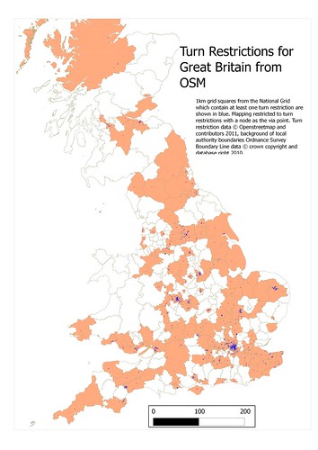
Turn Restrictions for Great Britain
I continue the quest to find proxies for ground survey mapping.
Today I've looked at turn restrictions, (no left turn, no U-turn, and so on). Mapping this is still considered 'advanced': it involves relations, and until recently there was little editor support.
There are only just over 1600 turn restrictions mapped for Great Britain, a small number use ways as the via point (I've done this for No U-turn restrictions), and one uses a relation as the via point. This analysis is restricted (sorry) to the more conventional ones which use a node as the via point. The map shows both local authority areas, with at least one turn restriction, and 1 kilometre squares of the National Grid with at least one turn restriction.
OSM is obviously in the very early stages of adding this sort of information. I would expect most moderate sized towns to have at least one turn restriction (for example, ensuring traffic flow along the main street). I think we can also infer that even dedicated mappers have not yet included turn restrictions in their 'must do' mapping targets.

Really interesting map - I'm hoping that Potlatch 2 will lead more editors to map turn restrictions. However, a lot of turn restrictions are implicit from one way streets, so a lot of moderately sized towns may not actually need any explicit turn restrictions.
ReplyDeleteA good point: I'll see if I can add the end nodes of one-way streets.
ReplyDeleteSo we have 1900 Turn restrictions mapped. That compares to 5 - 6000 turn restriction bug reports on MapDust.com
ReplyDeleteYes, I think that summs up the poor state of turn restrictions quite nicely :-S Other routing related tagging like max speed is not much better either.
Hopefully including a router on the main page will help somewhat in that respect.
Following on from enervation's comment, I've tried to add a sensible layer of oneways to the map.
ReplyDelete