Friday, 28 February 2014

Floods of Transient Data

OpenStreetMap was not conceived as a platform for storing transient geographical data: traffic jams, road works, road closures, earthquake damage, barricades in city centres or floods. However it is used widely for holding such information for all cases except the first.

The recent flooding in Britain has led to a degree of questioning about how we should hold such data, but it has also reawakened an interest of mine in seeing if OpenStreetMap data can be used for simple modelling of hydrological systems.

First I discuss transient data and look at a different aspect of flooding, the availability of suitable data, in the second part of this post.

Flooding in the Somerset Levels mapped on OSM
using key natural=water
copyright OSM contributors, CC-BY-SA

Friday, 14 February 2014

Diversity isn't always what we think

Yesterday I had to find a Western Union outlet to receive a money transfer from a friend who lives in a country where he cannot enjoy the normal financial service amenities we have in Europe and North America.

Western Union outlet in Hyson Green
Source: OpenStreetView

It was an eye-opener. There are lots of these outlets locally. I was aware of them, but had never considered that the availability of money transfer facilitates was worthy of mapping.

Having had to search for locations on-line and noticing that the information even on the Western Union site is  out-of-date in places I have changed my mind. For shops with a Western Union or other money transfer outlet I am using money_transfer=Western Union. Standalone premises can be tagged amenity=money_transfer as suggested on the OSM wiki.

This experience reinforced my own awareness that, however conscientious I am in trying to map things, my decision about what to map is heavily affected by my own experiences. Although I am strongly aware that Nottingham is a city with people from all over the world (how can I not be, our immediate neighbours are from Africa and Asia). This has been reinforced when mapping shops, restaurants and takeaways. Similarly, although I have a friend who makes a living out of offering telecom services to Bangladeshis living far from home, and have noticed how many shops have Lebara branding, I'd never thought about how this sort of thing should be mapped.

In a recent post I mentioned that I worry that tagging of woodland may act to reduce the diversity of mappers in terms of interest and expertise. This is just another example of how increasing diversity within OpenStreetMap is not just about extending involvement from different groups, but also recognising that different people have a variety of needs when it comes to things which get mapped.

A part of getting involvement from different groups is showing that OSM is relevant to them directly, rather than as a substitute for Google Maps. We've achieved this for wheelchair users in large part because of the involvement of Sozialhelden, and tactile maps have received a lot of attention because user Lulu-Ann has consistently championed them for a long time. Champions such as these have extended the horizons of every OSM mapper. (It doesn't have to be an obvious diverse theme, either, bahnpirat championed the mapping of power lines, which turns out not to be as geeky as it seems). The most obvious OSM champion, is Mikel Maron. His passion and action in taking mapping to marginalised communities ultimately led to the Humanitarian OSM Team, which is now a significant actor across the globe within the humanitarian sector.

I therefore think that increasing diversity in all its forms within OSM means nurturing our past, present and future champions. These people can help everyone see things differently.

Tuesday, 11 February 2014

Exemplar locations for woodland mapping: 1 Garrotxa

In order to get a better idea of the issues involved with my more detailed suggestions for tagging woodland, I've been searching for suitable locations which have a range of different woodland types, and data available on the woodland types. For reasons I've discussed previously I'm restricting this examination to the Holarctic region.

Cap on anem? // Which Way?
Fayeda d'en Jorda, Beech Wood in Parc des Volcans, Garrotxa

In the main I am looking for data sets either held on a national or regional level. To ensure comprehensive coverage this pretty much means looking at official datasets.

Fortunately most countries in Europe, the US , Canada and Japan have over recent years collected a lot of useful data under national forest inventory programmes. Other sources are comprehensive vegetation surveys, carried out by national biodiversity conservation bodies. Only a fraction of this data is readily available on-line, and might not be in a readily digestible form.

To date I have selected a small number of places. Most areas are mountainous so as to have a broader range of woodland types in a smallish area. Areas which are transitional between broader biomes also increases the heterogeneity. The first I describe here: the area of the Volcanic Natural Park around Olot in Catalonia.


Hunting Woozles in a 10 billion acre wood, .. or is that forest

This post is the first part of a series amplifying my talk at State of the Map 2013: "Zone de Combat".

Rather like Winnie the Pooh and Piglet wandering around Hundred Acre Wood in search of imaginary woozles we have been going round in circles in the woods. Or is that forests?

Cottonwoods
Infrared photo of Cottonwoods in Utah exposes hidden beauty of woodland
Cottonwoods by arbyreed, on Flickr CC-BY-SA

We have a little more than 40 hectares of woodland to care about: there are about 3,425 million hectares of woodland on the globe, covering around 23% of the total land area.

Since I got involved with OSM, 4 and a half years ago I've seen the mapping of many other objects has achieved a very fine level of detail. We can lovingly worry about the minutiae of mapping busbars in power sub-stations, or whether pubs have stone floors and real fires, or which king or queen was alive when a post box was built, or the number of flames in gas lights. These demonstrate that we are perfectly capable of mapping a lot of detail.

On the other hand there are many things where we have failed to delineate important distinctions when we map them. This is particularly true for woodland where we have two widely used tags which are virtually synonymous (landuse=forest and natural=wood). The problems have been rehearsed endlessly on the Wiki, and on OSM Help, so we have a pretty good handle on them, but there has been little concrete action. I think we have argued too long about the respective semantics associated with forest and wood. And, by the way, I'm as guilty as anyone else.

To coin a phrase "we have not seen the wood, or forest, for the trees".

Friday, 7 February 2014

Looking for footpaths in Hickling Notts

I thought I'd follow up my post about the Foolow Hole with an account of an early morning spent last Spring searching for public rights of way in south Nottinghamshire.

Old-fashioned fingerpost at T-junction S of Hickling
Public Rights of Way (PRoW) in Nottinghamshire are much more poorly mapped on OpenStreetMap than those of Derbyshire. It is safe to say that paths as a whole are much less well mapped let alone checked to see if they are Rights of Way.


Sunday, 2 February 2014

Mapping a Hole

I don't get to do much countryside mapping these days, so when I learnt that my sister and friends had rented the Youth Hostel at Bretton it seemed like a good idea to pay a visit for the day. My motivation was that just before Christmas Day a very large hole had appeared in a field close by (~ 800m).

Sinkhole from Bretton Ridge:
© Copyright Graham Hogg and licensed for reuse under this Creative Commons Licence.

Thursday, 16 January 2014

Lamp-posts and Botanical Records

Readers of this blog will know I have an fondness for using Local Government Open Data on the positions of street lights (see here, here, here and here). Over the last couple of weeks I've found another one.

Newly planted Quercus robur next to Derby Road Nottingham
note lamp post!

My original reason for buying a GPS was to make it easier to record wildlife records: I'm only 5 years into the minor distraction called OpenStreetMap! However, over the New Year I managed to drag myself away from addresses and postcodes and participated in the BSBI (the national botanical society) New Year's Day Plant Hunt. This is a relatively recent innovation, but has captured the attention of more and more botanists. The idea is to find as many different species of plants in flower during a 3 hour survey window.

Common Knapweed
One that got away. I missed this fine Common Knapweed Centaurea nigra on Jan 1.

Many people have been intrigued by common flowers appearing out of season. (Of course, some, such as Gorse are rarely seen out of flower ("When gorse is out of bloom, kissing is out of season"). Milder winters almost certainly due to global climate change are an important factor in allowing some plants to continue flowering. In other cases management of the land can cause plants to make new growth in the Autumn. Another possibility is that because the length of the day is the same in the Autumn as in the Spring that plants respond to some photoperiod effect. I've been noticing these things for years but never recorded them in a systematic way.

Green Alkanet
Green Alkanet Pentaglottis sempervirens
An attractive enough flower, both for bees and people, but a pernicious weed which seems to infest everywhere.

Tim Rich's very successful expedition in Cardiff on 1st January 2012 really set the ball rolling. Tim is a professional botanists, co-author of the Plant Crib, an indispensable guide to difficult plants, and author of a number of specialised to very specialised identification guides. Amazingly for someone who has been a bedrock for supporting amateur botanists across the country over the past 20 years, he is also out of work.  He's not the only one: it seems each year I get more mail bounced back or a new email address for a museum professional who has 'been let go'. (For non-naturalist readers, taxonomists are roughly equivalent to sysadmins in the botanical world: lots of things wouldn't happen without them, but they're not noticed when things are going OK).

Yarrow Achillea millefolium : 7057
Yarrow Achillea millefolium
Yarrow plants seem to thrive at this time of year, rather than just 'hanging on in'.

Another aside, people like Tim also play another non-obvious role: that of encouraging future generations of scientists. Many kids start out with an interest in natural history which can, if encouraged, lead to a careers in a whole slate of economically important areas such as medicine, and molecular biology, and not just ecology. Reducing the number of able scientists in museums who also perform substantial outreach and education activities, is eating the seed-corn for far more than just their direct specialisms. At least one British Nobel Laureate was inspired in this way.

Anyway, back two years ago I was really pleased to hear Tim on the Radio 4 Today programme describing his first plant hunt: my casual interest was validated by a similar interest by a serious professional botanist.

Red Valerian Centranthus ruber
Red Valerian Centranthus ruber, growing in Churchyard car park.
Normally a very vigorous population of these pop-up all over the churchyard in Summer.

I managed to do about an hour's surveying on January 1, 2013, but still managed to find 20 plants in flower. This year I was determined to do better. I wasn't able to join the Leicester botanists who set the bar high with 59 or so species. The weather and my health prevented me finding much before the end of the year.

However, the rain stayed off on the afternoon of New Year's Day, which meant I could visit all the places I'd already seen plants in flower, and spend more time looking for others. My main locations for searching for plants where: two areas of parkland ,both campuses of Nottingham University; grass verges along some local roads; a local churchyard; and the car parking around local shops. Many plants survive in the road gutters, or at the edge of the pavement and a wall or on little patches which only get cut from time to time.

Ribwort Plantain: 7079
Short daylight hours meant that it was getting dark towards the end of my survey
Ribwort Plantain Plantago lanceolata

My advantage is that I have used most of these places to learn how to identify plants: I thus know exactly where to find around 400 species of flowering plant within 1 km of home. Naturalists call this 'patch watching' (The Urban Birder talks a lot about the concept): it works because one builds up an intimate knowledge of one's local flora. Things which are new or unfamiliar stand out remarkably quickly in this context (in computing terms, its a very efficient vdiff). Unfortunately familiarity with a patch can also mean that one struggles to identify ordinary plants in an unfamiliar context.
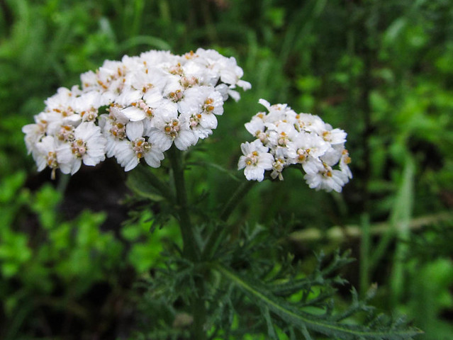
unprepossessing A bit of unpreposseing highway verge: 7056
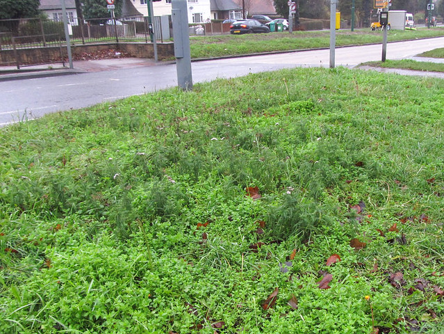
A bit of unprepossessing highway verge, a typical place worth hunting in.
At least 6 different plants in flower here, fortunately it hadn't been cut in late Autumn.
Plants: Yarrow, Groundsel, Dandelion, Chickweed, Wall Barley and Shepherd's Purse.

For my recording I used the Obsmapp Android app, which meant that I didn't have to carry much with me. The survey time was about right before the battery ran down. I also collected samples of many of the plants to double check my identifications down a microscope when I got home. (A cold dank January day with poor light is not the place to check if a plant has star-shaped hairs on the undersides of it's leaves).

One minor problem with Obsmapp is that you need to make an identification at the time (or at least use a known species as a place holder). Now like many naturalists I'm not great at identifying grasses or dandelion-like flowers. For the latter I used a place holder species and checked the identification when I got home. However there were several grass specimens which I was not at all sure about. I've never chunked grasses in such a way that I can make a good approximate identification: I have to take them home and use a key.

Red Dead-nettle Lamium purpureum : 7047
Red Dead-nettle Lamium purpureum

This meant that I could not record the geolocation of these specimens through Obsmapp. Fortunately, street lights were to hand: instead I took a photo (geolocated, but that's not too important) of the nearest lamp-post's asset identifier. I then used the Nottingham Open Data Street Lamp dataset to get the lat/lon for the lamp-post and added these records into Observado once I got home.

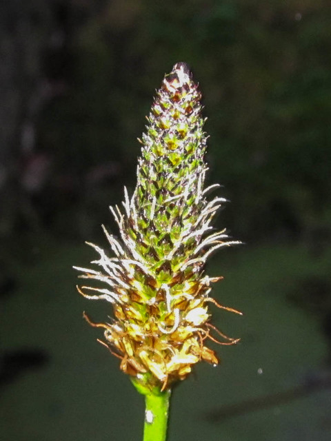
A tuft of False Oat Grass was under this lamp post


All in all I managed to get 40 different species (my unknown grasses all turned out to be False Oat Grass). This was a very gratifying total. Annoyingly, I walked straight past a fine example of Knapweed which I found a couple of days later, and I noticed a Gorse bush which I was unaware off only on Monday!

One other aspect of looking for flowering plants at this time of year is that often they are stunted and don't always have the same habit as in the Spring and Summer. It is therefore an excellent way to challenge and improve one's identification skills. Not least know that in Britain we have Poland and Clements' Vegetative Key for identifying the plants when not in flower. I also used Eggenberg's lovely Flora Vegetativa which has many fine illustrations which complement the Vegetative Flora. (even though this is book on Swiss plants it works very well in Britain).

The other day I noticed a newly planted oak tree (one of 10 trees planted at the behest of our local Councillor Sally Longford to replace ones which had to be felled because of disease). Although I took geo-located photos I took great care to include 2 lamp-posts to enable me to locate this new tree accurately before adding it to OpenStreetMap.

Ophrys apifera Bee Orchid
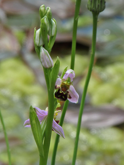
Bee Orchid at Nottingham University Jubilee Campus
(location originally noted using lighting asset numbers)

I've previously used the asset numbers on the lighting in the University to check on locations of some Orchids in the Jubilee Campus, and I've also used them as markers when trying to map the trees in a belt of woodland more accurately.

So for urban wildlife, lamp-posts can be an invaluable resource for accurately locating specimens!