Since 2015, East Midland mappers (and one or two from further afield) have met close to New Year to fill gaps in footpath mapping on OpenStreetMap. This year we met at Lees, a small village, only a few miles west of Derby, but distinctly rural nonetheless.
 |
| SomeoneElse & will_p joining trigpoint & me near Grange Hill Farm |
The area roughly between
Lees and
Longford and south of
Long Lane (which follows the line of a Roman Road) has long been a hotspot of unmapped paths on OSM.
 |
Hotspots of public rights of way missing from OSM in the East Midlands
Lincolnshire is too far for our gathering so for the past two years we have met at each of the areas to the W & SW of Derby. The other area to the NE of Derby has been largely filled in during the year. |
Lees is just about the only place which can truly be called a village: even the places with churches — Long Lane village, Trusley and
Thurvaston — do not have much more than a church, a few houses and a couple of farms. Other hamlets, such as Osleston, are even smaller, but have field signs that in medieval times they were much more extensive. I haven't been able to find much on the historical development of the area which might explain this rather unusual settlement pattern.
 |
Solar panels by the stream just outside Lees.
This gives a good feel for the countryside: sheep grazing (on ridge and furrow), many hedges with scattered standard trees (usually ash), farm ponds surrounded by trees (willows & ash), streams with a narrow band of riparian woodland (willows, poplars, hawthorn & blackthorn scrub). |
The countryside is unremarkable: low rolling hills on Mercia Mudstones, but without the deeply incised streams, as found, for instance, in the Trent Valley. The farmland still seems to be predominantly pasture, with relatively little subdivision of fields for horses as is now common near towns. Farmsteads are large, and either heavily modernised with massive industrial sheds or apparently mouldering with decaying brick outbuildings.
 |
| Farm out-building at Osleston |
The formula for these gatherings is now fairly set: meet at 10:30, walk, usually separately or perhaps as a pair for a couple of hours; gather at a pub for lunch from 12:30 onwards; repeat the walking in the afternoon. Although this limits the actual mapping time it provides a proper opportunity for everyone to get together, allows scope for people with other commitments, and allows a bit more co-ordination for the afternoon. It is also not unknown for the weather to be unfriendly in Britain, so the provision of the chance of a bit of dry shelter is always a good idea.
 |
| Early results of the mapping, new (or changed) paths in blue, hedges & fences in red |
We had a reasonable idea
of suitable targets when we met.: I had taken the chance of a trip to Shrewsbury in October to make a preliminary recce of the area and of the pub; SomeoneElse had mapped one longer distance route (the
Bonnie Prince Charlie Walk through the area too); and Dudley passes through
Kirk Langley on his way to work.
 |
Lees, detailed mapping by will_p
(from SomeoneElse's map) |
Will, as he did last year, combined mapping villages (Long Lane, Lees) with footpaths. I went off to explore the path system to the west of
Osleston; SomeoneElse headed south to
Trusley; Trigpoint arriving from the west, looked at paths around
Sutton-on-the-Hill, and Dudley worked on an intricate network of short paths around Kirk Langley.
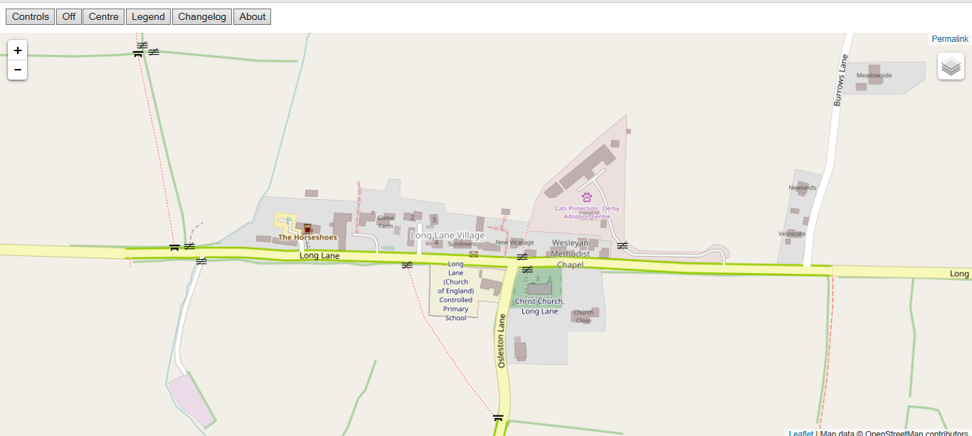 |
| Detailed mapping of Long Lane village by will_p |
During my mapping I made an effort to capture panoramas of the countryside from suitable vantage points to double check against aerial imagery when mapping hedges, farmyards, buildings, and the type of farmland. I hope to be able to use this to continue to add detail.
 |
Tight corner at Russel's Old Place, Osleston.
Only the verge on the left is actually a verge, the grass on the right being part of a garden. |
One particular problem in this area is that the roads are narrow (one car wide), and often little in the way of verges. The lack of verges is a hazard for walking along those sections of road, but also restricts viable places to park. SomeoneElse's custom map render therefore shows
verge key values for minor roads as can be
seen here.
 |
| Trigpoint trimming back blackthorn on a fairly typical footbridge with a stile at one end. |
We all went our different ways for the morning session, and through a quirk of our choices did not touch the area immediately to the west of Lees. In the afternoon we therefore set off as a group, divided into two parties, re-met again (see main picture) and split off again. This allowed us to cover most of the target paths in the area with the exception of one loop in the SW.
 |
| Violet Bramble Rust (I didn't entirely neglect looking at the natural history). |
 |
| A WWII pill box near Broad Chase |
These joint footpath mapping sessions are undoubtedly useful, but its worth putting this in perspective: we mapped around 25 km of paths. Derbyshire as a whole has over
5,200 km. So 5 of us spending about 12 hours walking paths only touched a half of one percent of the total. The real value is we can add much more detail to the area than the single mapper, and that detail can be enriched on return visits.
 |
An experimental rendering of OSM data for the area at 1:20k using QGIS.
The aim is to show similar features to the OS 1:25k Explorer maps. |
We are not done with this area there's perhaps twice as much more still to be surveyed, and the same is true of the National Forest area, S of Swadlincote, which we visited last year. However, it will not be long before the remaining hotspots are all in much less accessible parts of Lincolnshire. In a couple of years I'll need a different theme for these gatherings.


No comments:
Post a Comment
Sorry, as Google seem unable to filter obvious spam I now have to moderate comments. Please be patient.