Tuesday, 18 March 2014

Spring Woodland

Last Sunday we had fantastic weather, and where I'm staying in Berkshire I have countryside within a couple minutes walk. I therefore went out for what was supposed to be a short walk before lunch, but didn't get back until mid-afternoon.

I know the area well, and it's pretty well mapped, although there's plenty of scope for refinement because the bulk of the mapping was done purely by GPS before any aerial imagery was available. I was not planning any mapping activities at all, but as it turned out I realised this is a near perfect time for getting to grips with some of the complexities of mapping woodlands.

Wood Anemone, Bisham Woods
Wood Anemones, Bisham Woods
copyright mausboam

Wednesday, 5 March 2014

OpenStreetMap Nottingham goes to Derby

I've been very remiss in not reporting recent OSM Nottingham pub meetings.

Part of the idea of this blog was to give people a feel for what goes on at such meetings and who comes along, so this is definitely a failure on my part. (I should add that in the absence of simple social aspects directly implemented on the main OSM site, keeping the basic communications to keep people informed of these meetings is harder work than it should be, and when I'm busy with other things I tend to miss channels out or send reminders out too close to the event).

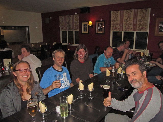
OSMers in Exeter Arms
(will_p, wja, Karen & MatSmith, blackadder and ChrisClemson)
Image courtesy of wja rights reserved
For some time, in fact before we went to Worksop to link up with the HOT Hack team, we've talked about changing the venue from time-to-time in the hope of making it easier for mappers elsewhere in the East Midlands to join us. Derby always seemed an obvious choice both because we know a number of mappers who live and work in Derby and because it's pretty accessible (I can reach the centre of Derby in 20 minutes by bus, only marginally shorter than the time to get to Nottingham City Centre, and 10 times further).

OSMers and HOTties, Worksop
Mix of local OSM folk and HOT hackers at Worksop, Sept 2013.
(Wonderchook, harrywood, IknowJoseph, bigfatfrog, FranBoon and others)

Consulting with the pub experts in the OSM Nottingham crowd gave two suggestions for a place close to the centre of Derby and handy both for buses and trains: the Brewery Tap and the Exeter Arms. I plumped for the Exeter Arms as from the descriptions by William and Andy it sounded a very attractive pub. The only downside of Derby is that two of the city's busiest mappers (Paul The Archivist and Rovastar) work in London these days.

When this meeting was announced on the talk-gb list Dudley Ibbet intimated he'd come along. I missed most of Dudley's talk at SotM in Birmingham, but did have a chance to chat to him later. Like Andy (SomeoneElse), Dudley is a stalwart mapper of footpaths. As I have rejuvenated my own interest in mapping footpaths, it seemed likely that footpaths would figure in our pub conversation.

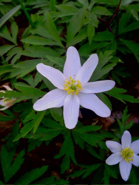
Coincidentally, I'd done a bit of mapping about 10 days before on one of those wet and windy days which have been so common in Britain this winter. I'd hoped to meet up with some Botanist friends, but I think they'd not been brave enough to venture out. I had a short walk at Charnwood Lodge National Nature Reserve along a footpath and in some access land. An hour was about as long as I wanted to stay out: I found some nice lichens and a few plant galls:

Podetia of a Caldonia spp.
Obligatory photo of something biological to accompany blog post on footpaths :-)
Podetia of a Cladonia lichen.

I chose a route back which wandered along country roads (the M1 had been pretty windy anyway) with the aim of noting as many footpath signs as I could. I started passing through the industrial town of Shepshed and managed to add a large number of pubs which distressingly were missing from OSM. When I came to update OSM with the information I'd collected I realised lots of the paths were on the map and had been mapped by a single user MatSmith, they just had not used the designation tag to provide the information which I'd been using to find missing footpaths. A little later in the week I noted a footpath somewhere else also mapped by Mat. For some reason I'd never noticed his contributions before: now I realised we had another major footpath mapper relatively close by. I took the obvious action and sent him a message about our meeting in Derby.

For the day I updated my comparison of PRoW data from rowmaps and OSM for Notts, Derbys and Leics. with the addition of a background layer from OS OpenData Meridian to make it a bit easier to locate things (I had this data readily available in PostGIS, so easier to do than titivate OSM data). Naturally footpaths did get talked about, but the realisation that my comparison was seriously inadequate for much of Leicestershire because of MatSmith's mapping, means I'm not publishing the latter map. I have however been working on some way in which we can highlight missing footpath data as a background layer for OSM editors without encouraging tracing from sources fraught with copyright problems.

Each orange dot shows where a PRoW meets an OSM highway which is not a track or path
(area is NE Leicestershire). PRoWs are shown with OS OpenData Meridian 2 layer for context.
Contains Ordnance Survey Open Data Crown copyright and database right 2012.

A couple of other topics came up:

  • Chris Clemson was asking about rendering tiles and running a web server. I've done this on a small scale on a local system with oldish infrastructure so was able to tell him about that side of things, but I've never tried with renderd which manages rendering according to user requests rather than blindly generating the whole tile set. TileMill of course provides a fairly easy to use way of generating a tile set, but I haven't tried to build my own viewer. I may have to get to grips with this for building FHRS tiles.
  • Andy (blackadder) talked about the possibility of having an OpenStreetMap Midlands gathering. This would probably be a day-time event in the Summer. Places like Stoke-on-Trent and Cannock Chase came up in discussions. Both are reasonably equally accessible from Birmingham and Nottingham/Derby (what Jones the Planner calls Brian Clough City) and are not so well mapped. Personally I'd be interested to visit Cannock Chase.
All-in-all a very profitable meet-up.

Upside. We had a really good turn out. It was great of Mat(t) and Karen to join us at short notice and also very nice that Blackadder came up from the MappaMercia crowd. So out of the 9 of us, 5 were joining us for the first time. Definitely coming back to Derby (in May).

The downside. The Exeter Arms is a great pub with lots of neat little rooms and what looks like good food (albeit a bit fancy: pubs which serve coffee with shortbread biscuits shaped like bones dipped in chocolate are hardly ordinary boozers):

unfortunately this meant it was very busy and the kitchen was maxed out! We probably need a slightly quieter venue!

Friday, 28 February 2014

Floods of Transient Data

OpenStreetMap was not conceived as a platform for storing transient geographical data: traffic jams, road works, road closures, earthquake damage, barricades in city centres or floods. However it is used widely for holding such information for all cases except the first.

The recent flooding in Britain has led to a degree of questioning about how we should hold such data, but it has also reawakened an interest of mine in seeing if OpenStreetMap data can be used for simple modelling of hydrological systems.

First I discuss transient data and look at a different aspect of flooding, the availability of suitable data, in the second part of this post.

Flooding in the Somerset Levels mapped on OSM
using key natural=water
copyright OSM contributors, CC-BY-SA

Friday, 14 February 2014

Diversity isn't always what we think

Yesterday I had to find a Western Union outlet to receive a money transfer from a friend who lives in a country where he cannot enjoy the normal financial service amenities we have in Europe and North America.

Western Union outlet in Hyson Green
Source: OpenStreetView

It was an eye-opener. There are lots of these outlets locally. I was aware of them, but had never considered that the availability of money transfer facilitates was worthy of mapping.

Having had to search for locations on-line and noticing that the information even on the Western Union site is  out-of-date in places I have changed my mind. For shops with a Western Union or other money transfer outlet I am using money_transfer=Western Union. Standalone premises can be tagged amenity=money_transfer as suggested on the OSM wiki.

This experience reinforced my own awareness that, however conscientious I am in trying to map things, my decision about what to map is heavily affected by my own experiences. Although I am strongly aware that Nottingham is a city with people from all over the world (how can I not be, our immediate neighbours are from Africa and Asia). This has been reinforced when mapping shops, restaurants and takeaways. Similarly, although I have a friend who makes a living out of offering telecom services to Bangladeshis living far from home, and have noticed how many shops have Lebara branding, I'd never thought about how this sort of thing should be mapped.

In a recent post I mentioned that I worry that tagging of woodland may act to reduce the diversity of mappers in terms of interest and expertise. This is just another example of how increasing diversity within OpenStreetMap is not just about extending involvement from different groups, but also recognising that different people have a variety of needs when it comes to things which get mapped.

A part of getting involvement from different groups is showing that OSM is relevant to them directly, rather than as a substitute for Google Maps. We've achieved this for wheelchair users in large part because of the involvement of Sozialhelden, and tactile maps have received a lot of attention because user Lulu-Ann has consistently championed them for a long time. Champions such as these have extended the horizons of every OSM mapper. (It doesn't have to be an obvious diverse theme, either, bahnpirat championed the mapping of power lines, which turns out not to be as geeky as it seems). The most obvious OSM champion, is Mikel Maron. His passion and action in taking mapping to marginalised communities ultimately led to the Humanitarian OSM Team, which is now a significant actor across the globe within the humanitarian sector.

I therefore think that increasing diversity in all its forms within OSM means nurturing our past, present and future champions. These people can help everyone see things differently.

Tuesday, 11 February 2014

Exemplar locations for woodland mapping: 1 Garrotxa

In order to get a better idea of the issues involved with my more detailed suggestions for tagging woodland, I've been searching for suitable locations which have a range of different woodland types, and data available on the woodland types. For reasons I've discussed previously I'm restricting this examination to the Holarctic region.

Cap on anem? // Which Way?
Fayeda d'en Jorda, Beech Wood in Parc des Volcans, Garrotxa

In the main I am looking for data sets either held on a national or regional level. To ensure comprehensive coverage this pretty much means looking at official datasets.

Fortunately most countries in Europe, the US , Canada and Japan have over recent years collected a lot of useful data under national forest inventory programmes. Other sources are comprehensive vegetation surveys, carried out by national biodiversity conservation bodies. Only a fraction of this data is readily available on-line, and might not be in a readily digestible form.

To date I have selected a small number of places. Most areas are mountainous so as to have a broader range of woodland types in a smallish area. Areas which are transitional between broader biomes also increases the heterogeneity. The first I describe here: the area of the Volcanic Natural Park around Olot in Catalonia.


Hunting Woozles in a 10 billion acre wood, .. or is that forest

This post is the first part of a series amplifying my talk at State of the Map 2013: "Zone de Combat".

Rather like Winnie the Pooh and Piglet wandering around Hundred Acre Wood in search of imaginary woozles we have been going round in circles in the woods. Or is that forests?

Cottonwoods
Infrared photo of Cottonwoods in Utah exposes hidden beauty of woodland
Cottonwoods by arbyreed, on Flickr CC-BY-SA

We have a little more than 40 hectares of woodland to care about: there are about 3,425 million hectares of woodland on the globe, covering around 23% of the total land area.

Since I got involved with OSM, 4 and a half years ago I've seen the mapping of many other objects has achieved a very fine level of detail. We can lovingly worry about the minutiae of mapping busbars in power sub-stations, or whether pubs have stone floors and real fires, or which king or queen was alive when a post box was built, or the number of flames in gas lights. These demonstrate that we are perfectly capable of mapping a lot of detail.

On the other hand there are many things where we have failed to delineate important distinctions when we map them. This is particularly true for woodland where we have two widely used tags which are virtually synonymous (landuse=forest and natural=wood). The problems have been rehearsed endlessly on the Wiki, and on OSM Help, so we have a pretty good handle on them, but there has been little concrete action. I think we have argued too long about the respective semantics associated with forest and wood. And, by the way, I'm as guilty as anyone else.

To coin a phrase "we have not seen the wood, or forest, for the trees".

Friday, 7 February 2014

Looking for footpaths in Hickling Notts

I thought I'd follow up my post about the Foolow Hole with an account of an early morning spent last Spring searching for public rights of way in south Nottinghamshire.

Old-fashioned fingerpost at T-junction S of Hickling
Public Rights of Way (PRoW) in Nottinghamshire are much more poorly mapped on OpenStreetMap than those of Derbyshire. It is safe to say that paths as a whole are much less well mapped let alone checked to see if they are Rights of Way.