Showing posts with label Woodland Mapping. Show all posts

Wednesday, 4 May 2016

Where have all the woods gone from Google Maps?

Very recently there was a nice post by Justin O'Beirne about the cumulative effect of changes to the cartography of Google Maps.  Richard Fairhust summarised his views on twitter:


This is just my (very) minor contribution to the discussion.

The Botanical Society of Britain & Ireland (BSBI) uses Google Maps as the background to their maps of plant distributions. Over the past couple of weeks I've been using it a lot because I've been interested in two things:
  • Where I might fund particular plants relatively close to where I live;
  • Which plants I see might be of interest to the county recorders.
As at this time of year many of the botanical highlights are to be found in ancient woodlands it's damn useful to see where the woods are when assessing the BSBI records. That's why I noticed woods disappearing from the Google cartography as one zooms in.

This screenshots shows successive zooms of an area in central Nottinghamshire which includes Clumber Park an two old woods, Gamston & Eaton Woods. The latter two are centre right above the village of Askham.


All woodland just disappears between these two zoom levels.

Here's the active map so one can play with zooming in & out.


Losing woods at high zoom levels is another example of loss of functionality. In practice it makes the maps layer useless for interpreting botanical data: I have to resort to using the satellite layer. Even that is not always easy because sometimes fields also appear dark green.

Google does use a couple of other green shades for things like parks, golf courses, and possibly nature reserves (see Sherwood Forest NNR near Edwinstowe). I don't know if these come on and off in a similar arbitrary pattern.

Wednesday, 16 September 2015

Plantations : woods, forests or something else?

Stand of trees at New Fen - geograph.org.uk - 636879
Poplars at Lakenheath
CC-BY-SA 2.0   © Copyright Alison Rawson and licensed for reuse under this Creative Commons Licence.
One type of woodland area I have alluded to a couple of times in the past are plantations (see here and here). I've always been frustrated at not having found good illustrations, but in the past couple of weeks I've noted a few which either already have good open images available or I've been able to snap a picture myself.

Plantations run the gamut from small areas to fully-fledged forests. In general what connects them is that the trees are planted in orderly rows, and the plantation has an expected lifetime, after which the trees will be harvested or replanted. Photographs enable some of the variety to be shown. In turn this should highlight the sorts of information we might want to capture by OpenStreetMap tags.

Wednesday, 9 September 2015

Shops in Coalville


I had not planned to do much mapping on the Bank Holiday Sunday: the day was set aside for a meeting of the British Plant Gall Society at Ryton Woods, Warwickshire.

Oak with Hazel coppice stools, Ryton Wood.
The ground layer changes here with bramble (in foreground) absent deeper into the wood.
Just to the left of the foreground hazel a bank & ditch can just be discerned. This is probably the remnants of a woodland compartment dating back to the Middle Ages.

The only thing I expected to map were paths in the wood, which surprisingly are almost all unmapped (hint to Mappa Mercia folks). This is one of the best areas of ancient woodland in the county and only a short distance from Coventry and Warwick. In fact, if anything, I would have expected to write about this wood which is mainly Oak with Hazel coppice.

Coalville, Hotel Street geograph-3151694-by-Ben-Brooksbank
Coalville : Hotel Street in 1988.
The Railway Hotel is now a day nursery, and the buildings on the left beyond have recently been demolished.
The Railway was one of a cluster of pubs adjacent to the level crossing and station: the others continue as pubs.
Source Ben Brookshank, Geograph via Wikimedia Commons

Tuesday, 2 September 2014

Woodland Cartography

This is an expanded version of my talk at sotm-eu:


I start by seeking inspiration from the many ways in which woods and trees have been shown on maps in the past, and then consider what elements we may want for OSM data, and how we might depict such elements.

Sunday, 13 July 2014

Upland woods in the Schwarzwald

I wasn't done with looking at woodlands from a mapping perspective in Baden-Wurttemburg. A couple of days after SotM I walked from the top of the gondola at Feldberg to the Feldberg summit and then back to Hinterzarten.

The first part of the walk was somewhat marred by a fierce hailstorm which left me fairly damp. However I recuperated by drying out a bit over Kaffee and Kuchen at the Baldenweger Huette below the summit.

Forest path, part of the Emil-Thoma-Weg.

Thursday, 3 July 2014

Weingartnermoor Woodland Walk : SotM-EU Mapping Workshop

At State of the Map Europe in Karlsruhe I used the opportunity to develop some of the themes I have already outlined for woodland mapping. Essentially I have three lines of attack:
  • extending the cartography of woodlands in OSM ;
  • finding richer ways of tagging woodlands in OSM ;
  • looking at how we can collect data about woodlands (mapping).
I didn't do anything about the second, but gave a lightning talk outlining just some ideas about woodland cartography (I got a few more over the course of the conference). For the latter I thought the best approach would be to get some OSMers in some real woods because real things are much easier to discuss than abstract ideas on the wiki.

We spend much of the conference listening and discussing abstract ideas, and (too) little time using the fact that we come from many countries to share our knowledge of tagging. (A little Guerilla Mapping is not out of place too). So this was a small innovation for an SotM conference too.

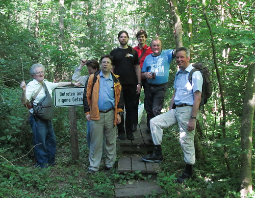
SotM-EU Woodland Workshop Participants
Participants on Woodland Mapping Workshop, Karlsruhe June 2014
(minus the author who can be seen in this photo)
I was fortunate in the first place that the Karlsruhe Stammtisch offered some good ideas and advice and the conference organisers chose to add the event to the programme. Secondly, I was fortunate in being supported by more OSMers than I expected: and I know I lost a few due to the early start (necessary to enable not missing the whole Hackday).


Tuesday, 18 March 2014

Spring Woodland

Last Sunday we had fantastic weather, and where I'm staying in Berkshire I have countryside within a couple minutes walk. I therefore went out for what was supposed to be a short walk before lunch, but didn't get back until mid-afternoon.

I know the area well, and it's pretty well mapped, although there's plenty of scope for refinement because the bulk of the mapping was done purely by GPS before any aerial imagery was available. I was not planning any mapping activities at all, but as it turned out I realised this is a near perfect time for getting to grips with some of the complexities of mapping woodlands.

Wood Anemone, Bisham Woods
Wood Anemones, Bisham Woods
copyright mausboam