I wasn't done with looking at woodlands from a mapping perspective in Baden-Wurttemburg. A couple of days after SotM I walked
from the top of the gondola at Feldberg to the Feldberg summit and then
back to Hinterzarten.
The first part of the walk was somewhat marred by a
fierce hailstorm which left me fairly damp. However I recuperated by
drying out a bit over Kaffee and Kuchen at the Baldenweger Huette below the summit.
At State of the Map Europe in Karlsruhe I used the opportunity to develop some of the themes I have already outlined for woodland mapping. Essentially I have three lines of attack:
extending the cartography of woodlands in OSM ;
finding richer ways of tagging woodlands in OSM ;
looking at how we can collect data about woodlands (mapping).
I didn't do anything about the second, but gave a lightning talk outlining just some ideas about woodland cartography (I got a few more over the course of the conference). For the latter I thought the best approach would be to get some OSMers in some real woods because real things are much easier to discuss than abstract ideas on the wiki.
We spend much of the conference listening and discussing abstract ideas, and (too) little time using the fact that we come from many countries to share our knowledge of tagging. (A little Guerilla Mapping is not out of place too). So this was a small innovation for an SotM conference too.
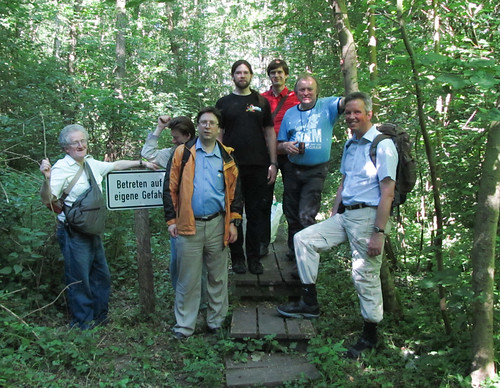
Participants on Woodland Mapping Workshop, Karlsruhe June 2014
(minus the author who can be seen in this photo)
I was fortunate in the first place that the Karlsruhe Stammtisch offered some good ideas and advice and the conference organisers chose to add the event to the programme. Secondly, I was fortunate in being supported by more OSMers than I expected: and I know I lost a few due to the early start (necessary to enable not missing the whole Hackday).
Before SOTM-EU 2011 I wanted to spend a bit of time in the Alps. This is a belated account of that trip.
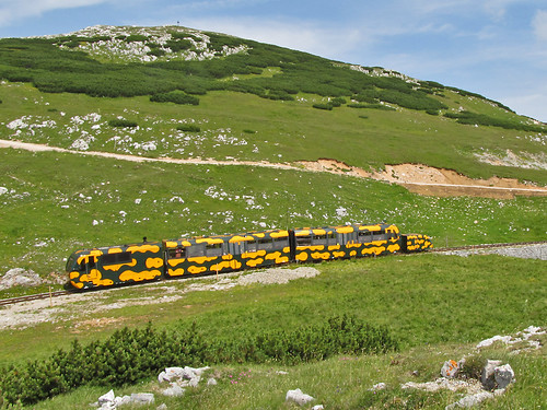
Salamanderzug near the top station.
It's been a few years since I've been anywhere in the Alps in Summer, and in the meantime I've improved my botanical knowledge enormously. So high on my list of things to do was to look at alpine flowers properly for the first time. This is pretty much incompatible with serious hiking: botanising takes time, it's eminently possible to travel at about 100 metres/hour.
I therefore wanted somewhere close to Vienna with mountains high enough to have an alpine flora still in flower, and some kind of mechanical uplift. The obvious choice was the Wiener Hausgebirge, groups of limestone peaks reaching over 2000 m about 50 km SW of Vienna I've known about this area for a number of years: when my brother lived in the Viennese suburb of Meidling, I went skiing on a local hill, the Zauberberg at Semmering. At that time I noted the peaks of the Rax-Schneeberg area from the wonderful switchback railway over the Semmering pass.
The village of Puchberg-am-Schneeberg is still a popular day-trip destination from Vienna, but in the past was a small spa resort. There's one large hotel and a smattering of smaller places. I stayed in the Bruckerhof which turned out to be a nice place in a good location at a great price. It is only a couple of hundred metres from the station, and set back from the main road.
Puchberg was pretty quiet in the evening. I had the impression most visitors were, like the guests in my hotel, of a certain age. I was troubled that I'd have difficulty finding a place to eat, as most people seemed to have dined by half-past six. However, the Schwarzer Adler not only did food, put had a proper pub-like atmosphere down to guys playing cards at the Stammtisch.
With an altitude range of around 1500 metres from the village at just under 600 m to the summit of the Klosterwappen on the Schneeberg at 2076m there was a huge range of interesting habitats to explore. The only downside was that most of the lowland hay meadows had just been cut: so I missed out on some obvious places to botanise. On my first afternoon I wandered (very slowly) up the zigzag track through pine woods to the little peak of the Himberg.
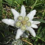
Edelweiss (Leopondtidum nivale)
The following morning I caught the Salamanderzug up the mountain. Even from the train there were special (and protected) flowers to be seen: Martagon Lily Lilium martagon (Türkenbund), Nottingham Catchfly Silene nutans (Nickendes Leimkraut), and Carthusian Pink Dianthus carthusianorum (Kartäusernelke). On the plateau the highlight was Edelweiss (Leontopondtium nivale) and masses of Mountain Avens Dryas octopetala (Silberwurzen). The latter gives its names to stages of the post-glacial Quaternary, so it's more than a pretty flower.
What has this to do with maps? Well the whole area around Puchberg and the Schneeberg itself are great exemplars of the sort of habitats (strictly biotopes) of the kind I would like to map.
Walking up the path to Himberg, I started in woodland dominated by Austrian Pine (Pinus nigra ssp., Schwarzkiefer), but on the northern side of the hill, this graded in Spruce Picea alba woodland (Tannenwald). Further along there were areas of Beech woodland (Buchenwälder). These are very noticeable: the pine wood has much more light than the spruce wood, and very different plants in the under-storey. Beech woods are different again. The plateau of the Schneeberg was a mosaic of grazed areas with a wide range of herbs and sub-shrubs (Mountain Willows, Mountain Avens, Dryas octopetala; Rose), and extensive areas of Pinus mugo scrub. These can be seen behind the train in the picture at the head of this entry. On the steeper sides of the Schneeberg, flushed areas within the Pinus mugo scrub had different plants again, such as Water Avens and . These were frequented by Fritillary butterflies. The scrub grades into forest, but at around 1000 metres there were many hay meadows, again with a different flora: it was around that I saw Martagon Lily.
The Schneeberg is also an important water catchment area for Vienna. There are a number of limestone sink holes in the summit area from which the general public is excluded to avoid polluting the supply. Again this is a feature which is still difficult to map in OSM.
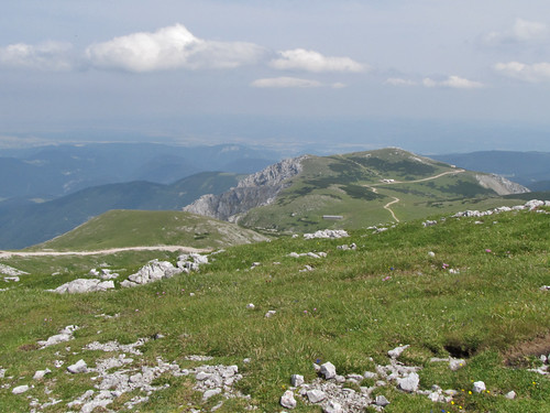
From near Klosterwappen looking across Ochsenboden
The official map made by BEV doesn't do a bad job of showing some of this information, despite really being a 1:50k topomap. It has a lot of toponymic detail, maps the Pinus mugo scrub, shows a lot of detail of the NE-face. It doesn't attempt to separate out the different forest biotopes: this is something I think is an eminently practical thing to do in OSM. The Schneeberg area is a great place to start.
Another aspect of the Schneeberg is that the NE face offers fantastic opportunities for spring skiing. I discussed this briefly with Felix Hartmann (extremecarver) after SotM-EU, who knows this area well. These are extremely well known, but not mapped on OSM. We don't have a sensible way to map this kind of ski route, nor for labelling features such as chutes, couloirs and gullies.
I visit Oakham about twice a year, and on my last couple of visits have done a bit of ad hoc mapping. The town, like the rest of the county of Rutland, was largely mapped many many years ago over one weekend by the Rutland Mapping party. It has received only a little attention since.
When I visit the Rutland Bird Fair I usually travel by bus, so the first thing I ever noticed about Oakham on OSM was that it was missing the road off the main street to the bus terminus. I was eventually able to fix this during the 2009 Bird Fair. I made a few other corrections, but also added an 'e' to Catmos Street, which provoked comment on talk-gb. (In my defence, OSM had Uppingham Road as Catmos Street for 3 years). Last year I added the Tescos car park and a couple of shopping arcades.
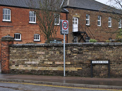
On Wednesday, I thought I'd sneak off and clean-up some mis-matches between OSM data and OS Locator. More or less as soon as we arrived I noted an unrecorded footpath, and then a small residential road opposite the library. This is the problem with Oakham, superficially it looks to be mapped in detail. In practice, there are still plenty of significant features missing. For instance, there are loads of 20 mph speed limits around schools (e.g., on Kilburn Road, Ashwell Road and Braunston Road).
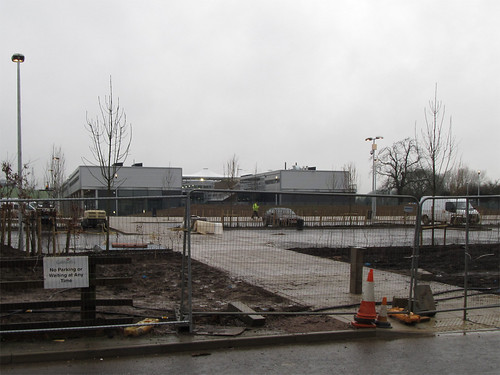
Furthermore, most mapping is now four and a half years old, and Oakham is changing. The most obvious change is a huge construction site on the Barleythorpe Road: the Catmose Campus which will house a sports centre, and new buildings for the main secondary school in the area. I walked past it in the rain (photo below): apparently the school may move in next Monday (a bit optimistic I'd have said). However, if the last couple of years are anything to go by, this dramatic addition won't get mapped in detail for a while.
Other changes are impending: Sainsbury's just had a planning application for a supermarket turned down, and Waitrose have one pending. In the summer there was a for sale sign over the Agricultural Showground suggesting that it has been zoned for housing. Even the shops on Mill Street which I've mapped show many changes from the same street a year or two ago as can be seen by looking at Google StreetView.
There are other issues with the mapping: both tagging and mapping practice have changed since 2006. Most GPS data is probably more accurate, and of course we have aerial photos, and OS data as well.
BUT, most of all, what we lack,is someone based locally. Someone aware of what is happening in the community, such as this interestingly acrimonious planning meeting. Someone able to pop down to the library or the study centre in the Rutland County Museum to check old maps or other sources for names; Someone who knows whether the sixth-form college is called "The Rutland College" or "Rutland County College", and , indeed, what's going to happen to it if Waitrose build a supermarket on its current site; Someone who can act as an advocate for OSM with groups like the formidably active local history society. Surely if someone is willing to compile a list of bells, clocks, scratch dials for Rutland, there might be one person interested in something as mainstream as contributing to a map. This is not just true for Oakham and Rutland, but for many places in Great Britain.
Not for the first time I wondered if a mapping party, consisting mainly of visitors, might have the same effect as an import. The town looks nicely mapped on the slippy map, so no-one notices that there's lots to check and correct: indeed if I regularly drove to Oakham I might not have noticed these deficiencies in the first place. I collected data in the rain with these doubts in mind. I'll map what I can, there is far more which needs to be checked, corrected, and enhanced than anyone can collect in a fleeting visit.
OSM's bard was having problems yesterday with Corine data for Ireland. It turned out that the Corine class 231 (permanent pasture) ran more or less continuously through Ireland from Malin Head to Kinsale Head. This created a single relation with around 17,000 members, the "rogue polygon" (see image). Needless to say required a lot of processing with osm2pgsql for rendering with mapnik. At least it might be accurate rather than the large healthcare facility that Google thinks exists in Letterkenny.
I learnt about the related EEA (European Environment Agency) project called the Urban Atlas. This uses a similar classification of landuse to Corine, but a much smaller minimum size for survey units. The maps produced have a lot of detail and look very interesting. Compared to some other countries the UK has only got coverage of a limited number of cities. But, Nottingham is included. In fact the Nottingham Urban Atlas covers a huge area apparently contiguous with the boundaries of the Districts of Erewash, Broxtowe, Rushcliffe, Ashfield, Mansfield and Gedling, and Nottingham Unitary Authority.
In some parts of Europe, such as Poland, Urban Atlas data is being prepared for import to OSM. Although not interested in the data for import I expected it data to be useful for two reasons in the first instance: completeness of coverage, and as a control for OSM tagging. The Corine division of urban fabric (roughly equivalent to OSM landuse=residential) makes useful distinctions with regards to density and continuity of urban areas, which, to date, are under represented in OSM. This type of distinction has a long history in landuse mapping. In earlier days it was concerned with urban areas which could be productive for fruit and vegetables. Nowadays, water run-off and nature conservation issues are probably more significant. As a mapper one is always aware of the difference, but I, for one, don't try and capture it explicitly. The Urban Atlas methodology has criteria which it should not be too hard to adapt for OSM, but we do need to think about appropriate tagging.
Of course the first area I looked at in the Nottingham Urban Atlas data was the two slices I've mapped this year. Part of the point of combining survey and Bing data is to capture quantitative information about landuse. So here is the area from the Urban Atlas, using the standard colour scheme:
The first thing which strikes me is that the Edwards Lane Estate is not given a uniform classification. This seems very odd: the estate is clearly a single uniform design including road widths, garden sizes, house types. I assume that it was planned with a specific population density in mind, and specific guidelines in terms of percentage of the area devoted to houses, gardens, open space and road infrastructure. Here's the same data with houses I've recently mapped in OSM : it's very clear that areas with identical numbers of identical houses have been assigned to different categories:
So note the darker red areas with code 11210 : on the ground this is indistinguishable from the rest of the estate (coded 11220) . All I can conclude is that the data were not subjected to ground validation: an overview of the methodology is shown in this presentation. Detailed inspection of other well-mapped areas reveals similar minor anomalies: industrial and commercial areas spilling over to residential blocks; areas in campuses (colleges, hospitals and universities) being incorrectly assigned to residential categories; and soon and so forth. These nuances probably don't affect the reliability of the data for its purpose, but they do reflect how the data was sourced. One issue might be how parcel boundaries are selected, which may have the effect of putting all of some shared resource in one parcel (such as a kids' playground). I'd hoped to find time to measure housing density based on OSM data for the shapes shown above, and thus have more confirmation. It will have to wait for another time.
The bottom line: this sort of data set can be created as a side effect of areas which have already been mapped in OSM. A small amount of additional tagging is needed on residential areas, but otherwise a comparable dataset can already be produced for much of the Nottingham area. The EEA should start considering OSM as a primary source for any extensions of this dataset in places like Germany and many parts of the UK. OSM data is likely to be more accurate, reflect better understanding of the locale, and be more up-to-date.
Postscript. I find it slightly boggling that I'm disparaging a data set which two years ago I would have thought was fantastic. It's great to find how powerful OSM is becoming.
SK53 received a Garmin GPS as a Christmas present in 2008. Foolishly he downloaded OSM, noticed a nearby street was missing, and promptly sold his soul to mapping. Since then he has mapped large parts of Nottingham, verified about half of Maidenhead, takes a PC on holidays for mapping, and now has 2 more GPS gadgets, but still feels the need for more. Further details on his OSM wiki page User:SK53