 |
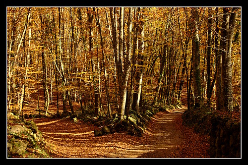
| Fayeda d'en Jorda, Beech Wood in Parc des Volcans, Garrotxa |
In the main I am looking for data sets either held on a national or regional level. To ensure comprehensive coverage this pretty much means looking at official datasets.
Fortunately most countries in Europe, the US , Canada and Japan have over recent years collected a lot of useful data under national forest inventory programmes. Other sources are comprehensive vegetation surveys, carried out by national biodiversity conservation bodies. Only a fraction of this data is readily available on-line, and might not be in a readily digestible form.
To date I have selected a small number of places. Most areas are mountainous so as to have a broader range of woodland types in a smallish area. Areas which are transitional between broader biomes also increases the heterogeneity. The first I describe here: the area of the Volcanic Natural Park around Olot in Catalonia.
I'm starting by experimenting with cartographic ideas: partly because my thoughts are a little better developed in this area, but also because looking at the cartography forces a deeper engagement with aspects of the data.
Spain was a fairly straightforward choice: I have a guide to trees and shrubs of Iberia, and two regional floras in my library; the national flora, Flora Iberica, is available on line; woodlands range from alpine to mediterranean with a substantial atlantic element in Galicia and Cantabria. In addition I know several places in Spain sufficiently well that I can add my own knowledge to the data and aerial photos available.
Olot, Alta Garroxta
I visited Olot after SotM-10 in Girona. My parents had visited a few years before and from their descriptions it sounded interesting. As I'd wanted to visit for a while it was high on my list of places to go after the conference. It's actually easy to visit from Girona in a day by bus (the fit can cycle).Olot is in the middle of a (probably) dormant volcanic area: the whole town is surrounded by cinder cones ranging in height from 100 to 300 m high, and in age from 700,000 to 11,000 years b.p. It is thus similar to the better known volanic area around Puy de Dome, in the Massif Central. Olot itself is a pleasant town of around 20,000 inhabitants, an old quarter under one of the volcanoes, and leafy newer districts stretching along the river. In one of these there is a very pleasant park with a botanical collection of the local flora, and a Volcano museum.
 |
| Volca de Santa Margardia from NW. Source: Wikimedia Commons Unfortunately this angle does not show the transition from Holm Oak to other trees (the Holm Oak, Encinar, woodland is mainly in shadow). |
The area is both a Natural Park and a Natura 2000 area.
The main Woodland types:
I've used data (mainly WMS) from the Inventario Forestal Nacional to examine the broader context of woods in this area.The map is based on selected WMS layers at a scale of 1:200k. This clearly shows the range of woodland types within a radius of 20km of Olot (and incidentally confirms my field notes).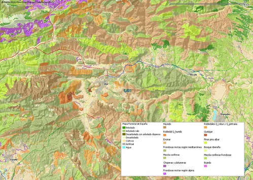 |
| Woodland distribution around Olot, Garrotxa. Source: IFN. Town and road network provided to aid context from OpenStreetMap. Shaded relief derived from SRTM Data. The area described above is located just below the IFN logo. |
- Los Encinares Quercion ilicis (Holm Oak woodland). The principal climax woodland of the Iberian peninsula. Holm Oak (Alzina in catalan, Encinar in spanish) is an oak with tough evergreen leaves. Like a lot of mediterranean plants it is a sclerophyll, and such woodland can grade into maqius (shruby sclerophylls) or garriques (sub-shrubs). In many parts of the peninsula these woods can be quite open, but this is not the case around Olot.
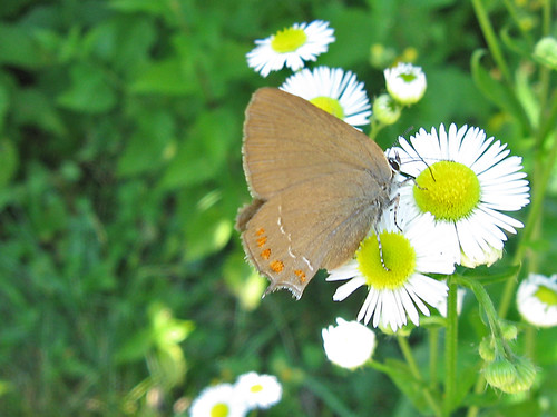 |
| False Ilex Hairstreak (Satyrium esculi) butterfly, Parc des Volcans The caterpillars feed on Holm Oak so this is a characteristic species of Holm Oak woodland. |
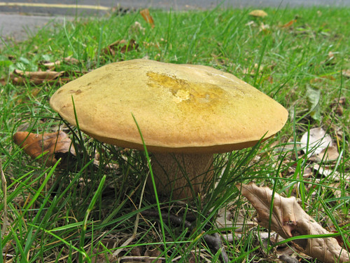 |
| Boletus luridiformis, a classic mycorrhizal associate of Beech |
- Los Hayedos Fagion sylvaticae (Beech woodland). In contrast this is a caudophyll woodland restricted to the Atlantic fringe of the peninsula, mainly at high altitudes (800-1500m). Around Olot this is pretty much at the edge of it's range. Beech woods have very dense share, which combined with the very slow decay of fallen leaves tend to little in the way of ground flora. On the other hand Beech trees are renowned for the huge number of fungi associated with them.
- Bosque ribereno. Populetia albae (Riverine gallery woodland). The damp substrate along river valleys enables this Euro-Siberian woodland type to thrive even in dry areas. The principal trees are Black Poplar, White Willow (Salix alba) and Crack Willow (Salix fragilis), with numerous shrub willows present as well. Around Girona, the woods also had many False Acacias (Robinia pseudoacacia), a North American tree which is naturalised in these habitats throughout Europe.
- Robledale Q. humilis. Quercion pubescenti-petraeae (Downy Oak woodland). The climax woodland of sub-mediterranean mountainous terrain. It also exists in patches on north facing slopes (ubac) as seen on the Volca. (Q. humilis is a synomym for Q. pubescens).
- Robledales. Quercion robori-petraeae (Pedunculate/Sessile Oak woodland). This is the typical Oak woodland community of much of Northern and Central Europe. It persists in Northern Spain mainly as a montane woodland..
- Frondosas mixtas mediterranean (Mixed Broad-leaved Mediterranean Woodland). In the main these seem to be closely related to the single species mediterranean woodland, often with a single dominant species, but with a much greater proportion of secondary species.

Nest of the Pine Processionary moth in a pine tree. Source: Wikimedia Commons. - Pinar pino albar Deschampsio-Pinion sylvestris (Scot's Pine woodland). In the Garrotxa area mainly on shaded north-facing slopes.
- Choperas y plantaneras. (Poplar plantations). Poplars are very fast growing trees, largely because they have no heartwood. Poplar plantations are a characteristic feature of river valleys throughout Europe. They are harvested and re-planted on a cycle of 20-30 years. In many places they are very recognisable because Poplar is a frequent host of mistletoe (Viscum album).
- Bujedo (Box woodland). Towards the mountains there are patches of Box, in this area usually in association with the Quercion robori-petraeae. Box tolerates shade well so these are often found on North-facing slopes from an altitude of 400 to 1650 metres. Elsewhere on the Iberian peninsula Box is a component of shrub communities.
- Frondosas mixtas de region alpina (Mixed broad-leaved montane woodland). These contain a mix of deciduous broad-leaved trees (a couple of examples examined from IFN data had as their commonest trees: Ash, 6%, Beech 4%; Sessile Oak 5%, Beech 4%). Most probably fall into the Fagion sylvaticae and Quercion robori-petraeae communities. These woods are similar to broad-leaved woods north of the Pyrennes, but are restricted to montane areas because of the influence of the Mediterranean climate.

Conclusions
Much as I would like to hold a woodland mapping party based in Olot, it is not a realisable short-term goal!Here are my initial conclusions regarding things which can be acted upon.
- Firstly, even my fairly casual observations of tree cover around the Volca San Marg were confirmed by the IFN data. This gives me great encouragement that basic details of many European woodland types can be captured by OpenStreetMap volunteers interested in this aspect of the countryside.
- Secondly, spending time researching data on this area has demonstrated that there is a vast amount of useful data held by governmental bodies on European woodlands: far in excess of the CORINE data which has already been used. Undoubtedly some of this information will become more readily available as government departments release more data and at least some is likely to have licenses suitable for incorporating within OSM. There is certainly scope to work with national, regional and local governments to persuade them to make more of this data available.
- Thirdly, if government woodland data does become available, it is even more incumbent on the OpenStreetMap community to develop more detailed and sophisticated tagging to cope with what is an extremely detailed and rich data requiring significant interpretation effort.
- Fourthly, the area definitely meets my criteria for diversity. My next steps with this area will be concerned with experimenting with different (non-thematic) ways of presenting the IFN data cartographically: particularly in the context of 'outdoor' or landscape mapping.
Coda
In writing this post I have tried to make good use of the on-line resources provided by the Ministerio , particularly the Inventario Forestal Nacional WMS service, but also shapefiles, and the relevant sheet of the National Forest Map. In doing so I encountered a number of problems using these with QGIS:- QGIS does not provide a means of creating a legend for WMS layers. Often one has to resort to switching layers on and off to determine which layer had a particular colour code. I had to create the legend myself (initially as an HTML page querying the relevant URL from the WMS XML, then converting this to PDF and finally PNG). For some reason this issue has been closed by QGIS developers.
- Querying the property of a layer often did not work. When it does it is very informative.
- Shapefiles use completely different attributes to those shown in the WMS layers: and include many non-forest land parcels.
- The Forest Map distinguishes woodland on the basis of "caduofillios" (deciduous) and "esclerophyllios" (sclerophytes), with information on the tree types added as an annotation.
- There is a hugely detailed manual on the IFN, with lots of information about how surveys are carried out, but a simple high-level guide to the data would also be advantageous (particularly for those whose Spanish is limited and 200+ pages is rather taxing).
- As is often the case the license under which the data are made available is not particularly clear.
Thank you so much for sharing a lot of this good content! I am looking forward to seeing more!c
ReplyDelete