 |
| Old-fashioned fingerpost at T-junction S of Hickling |
Completeness of PRoW Mapping
The two maps below show a comparison of the two counties. This uses data from the county councils which has been given to Barry Cornelius to host on his rowmaps.com site. This data is very useful, BUT in most cases the basis on which the data are made available are not at all clear. However, many councils seem to think they have discharged their responsibilities in making the data available in this way. Broadly, the data is probably fine when used in the privacy of one's own PC, but any other use may risk infringing copyrights both of the councils (who probably don't care) and of the Ordnance Survey (who care a great deal).From an OpenStreetMap point of view, these data are not terribly useful. Even for data licensed with the OSGB OGL it is not clear whether their use within OSM would infringe the rights of OSGB. Therefore about the only thing they can be used for is to identify candidate PRoWs and go out and map them. Of course a paper map can be used for the same thing: as long as everything is surveyed on the ground. In general it's a bad idea when mapping to carry a non-open map: there is a risk of copy things from the map not the landscape.
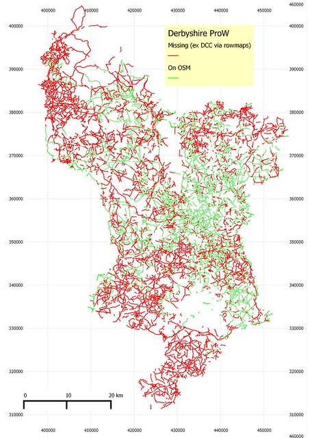 |
| Comparison of actual PRoW in Derbyshire (red) with those mapped as such using designation tag on OpenStreetMap (green). Grid is GB National Grid PRoW data copyright Derbyshire CC and Ordnance Survey OSM data copyright OpenStreetMap contributors Image copyright SK53, CC-BY-SA (you must include the above copyright statements: I didnt put them directly on the image). |
- I took all highways with a suitable designation tag
- I buffered tby 10, 50 and 100 metres
- I then did an intersection between these buffers and the rowmap data
- I plotted the data from the intersection above the complete rowmap data
 |
| A similar diagram for Nottinghamshire |
I'd expected counties in the S of England to do somewhat better, but this is not obviously the case:
 |
| and for East Sussex |
The areas with substantial coverage here highlight the complete absence of mapping rights of way in the rest of East Sussex.
Hickling
When I started with OSM I thought footpaths would be my main mapping target: in practice just improving the City of Nottingham has been my main focus for years. Fortunately SomeoneElse is a prolific mapper of footpaths, and we all benefit from a natural division of the workload. However he cant be everywhere so the rest of us need to do what we can. I happened to wake up very early one morning in June and couldn't get back to sleep so decided to go out before breakfast and do a little bit.
My chosen target was Hickling, a nice little village in the Vale of Belvoir. It is not only a nice place to walk, but is one of the southernmost parishes in the county, and, crucially, contains a tiny piece of an octad for which I had done no recording of Plant Galls. I therefore set out to find and map a few footpaths: I marked targets sites to examine on an OSM map .
It was very damp and misty when I got to Hickling and I was quickly able to establish one prospective path did not exist, and find two more along Green Lane. From the village itself I traced a network of paths to the top of the local hill, called Hickling Standard, and found a field full of wild flowers;
 |
| A Foxtail grass in full flower, Hickling Image copyright SK53, CC-BY-SA |
I'm not sure if I this is a proper meadow, although it certainly looked like one that morning. I also found a few galls, including this one on Walnut leaves: there were a lot of planted Walnuts at the top of Hickling Standard.
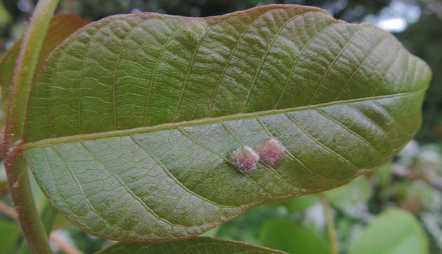 | |
| Hairy bulges on the leaflet are galls caused by a mite, Aceria erineuscopyright mausboam on Flickr |
I drove along the road to Long Clawson (home of a Stilton Cheese creamery) and stopped at the county border. On route I had failed to see any footpath signs on the North side of the road. Before I set out I had made sure there was a footpath which would take me in to grid square SK72. I turned round and drove slowly back, still no signs. So I got out of the car and walked up to the three gates which seemed likely: one led up a track, one into a field of cows and the last had a large log in front to the gate. At this point I gave up.
 |
| Start of un-signed (and probably not accessible) footpath. I failed to include the big log obstructing the gate in the photo. |
All in all the expedition had mixed results: I only found about half of my target footpaths and although I found 11 species of plant galls, I failed to search for them in SK72.
When I got home I emailed the Council footpath officer, and received a very helpful and prompt reply. The (non-dimpled) path through the wheat did go where I thought it went, but the farmer hadn't reinstated the line once his crop was growing. The other path does exist, but because it does not connect to the rest of the footpath network (it just goes to the bank of the Grantham Canal) it is unsigned. Now for walking that's pretty useless, but a quiet path with hedgerows is perfect for a bit of cecidology.
Once again I discovered that tracking down footpaths is not as easy as one would think.
To achieve good footpath coverage in OSM, we really need the help of people who have been wandering them for years; The Ramblers, local footpath preservation societies and the like. I made an advance to one locally, but was rebuffed in such a way that I didn't feel like trying again. This is a shame as many of these organisations tend to have a membership mature in years and not so tech-savvy as the OSM community: there's plenty of places for synergy. And it's needed, in 2026 all public footpaths not properly documented will cease to exist: and we know how onerous it can be getting that sorted out for just one footpath.
It's not all frustrating: I found this very attractive little moth, Pseudargyrotoza conwagana, resting on a leaf:
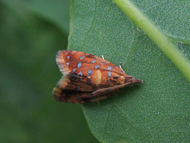 |
| 1011 Pseudargyrotoza conwagana by mausboam, on Flickr |
No comments:
Post a Comment
Sorry, as Google seem unable to filter obvious spam I now have to moderate comments. Please be patient.