I have long been a believer in the need to document OpenStreetMap survey data as thoroughly as possible.
I have a large archive of audio files, GPS traces, and tens of thousands of photographs. These span back to late 2008 when I started contributing to OSM. From time to time these prove useful, for instance, I had very precise documentation for my evidence at a Public Enquiry.
However, sharing such archival information with other mappers is difficult. It's not even straightforward for me to locate stuff. I have used OpenStreetView (OSV) since it was announced at SotM Girona. It is difficult to share photos using OSV, and the interface has not developed since 2010.
I was therefore very interested to learn about Mapillary, but was initially put off by the licensing. When they changed the licensing I was more interested. At SotM-EU Karlsruhe I was able to chat with Yubin after hearing his talk, which convinced me to give it a go. As I've said before, I regret I did not do this the following morning when full documentation of our walk at the Weingartnermoor would have been very useful, not just for mapping this particular place, but for discussing how to map woodland.
I don't have an Android phone which is compatible with Mapillary so I
have had to do things manually. This is a little tedious, so I tend to
keep the creation of sequences for things which are either simple or of
particular value.
Showing posts with label footpaths. Show all posts
Showing posts with label footpaths. Show all posts
Monday, 4 May 2015
Saturday, 10 January 2015
New Year footpath mapping with Mappa Mercia near the Fauld Crater
My first countryside excursion of 2014 was to investigate a man-made hole. For 2015 I choose a different bigger hole which I've meant to
visit for a long time: the Fauld Crater. What was different this year is
that we made it an OpenStreetMap mapping and social event!
I'd mentioned at our last pub meeting of the year that I fancied doing some footpath mapping between Christmas & the New Year. Coincidentally Rob Nickerson of Mappa Mercia
asked if we were organising anything after Christmas. So the idea of 2
or 3 of us getting together grew to the notion of linking up with Mappa
Mercia. So in the end the meeting had quite a diverse set of
goals:
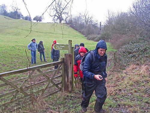 |
| Mapping footpaths for OpenStreetMap near the Fauld Crater, East Staffordshire |
- Do some mapping together
- Walk and map unmapped footpaths
- An excuse for a post-Christmas walk
- Link up socially with Mappa Mercia
- Initiate another type of OSM activity in the (East) Midlands
Monday, 14 April 2014
10 years of footpath mapping for OpenStreetMap
On a Saturday in late March I joined Nick Whitlegg, one of the earliest OpenStreetMap contributors, for a session mapping footpaths in the Weald. I was introduced to Nick several years ago on the basis that we were both walkers. But this was the first time we'd actually done a walk together, and my first opportunity to see how a real expert on footpath mapping did things.
 |
| Nickw with lots of footpath detail needing mapping near Ockley, Surrey |
Friday, 7 February 2014
Looking for footpaths in Hickling Notts
I thought I'd follow up my post about the Foolow Hole with an account of an early morning spent last Spring searching for public rights of way in south Nottinghamshire.
Public Rights of Way (PRoW) in Nottinghamshire are much more poorly mapped on OpenStreetMap than those of Derbyshire. It is safe to say that paths as a whole are much less well mapped let alone checked to see if they are Rights of Way.
 |
| Old-fashioned fingerpost at T-junction S of Hickling |
Wednesday, 2 October 2013
OpenStreetMap at a Public Inquiry
Summary (tl;dr)
OpenStreetMap featured in a Public Inquiry about whether a particular route was a Public Right of Way (PRoW). I appeared as a witness at this Inquiry for Paul Sladen (another OSMer) regarding how it has been mapped on OSM. This post describes the unusual circumstances as to why the status of Lenton Road path is controversial, a bit about the history of the path, details of my statement and the hearing, and a little bit about other uses of OSM in official planning processes. |
| Gate at the Lenton end of Lenton Road. The installation of this gate and later locking of the gate at night time was one of the sources of disagreement about the status of the footpath. Source: Mick Garratt on Geograph via Wikimedia Commons |
Tuesday, 26 July 2011
Footpaths in Carmarthenshire: What's the point?
Late in June I spent nearly a week near Carmarthen. I thought I'd get to know some footpaths local to where I was staying.
Subscribe to:
Posts (Atom)