Showing posts with label biological recording. Show all posts

Sunday, 14 October 2018

Creating MapMate Picture Files for Ireland

H34 Base Map for Map Mate Hillshaded
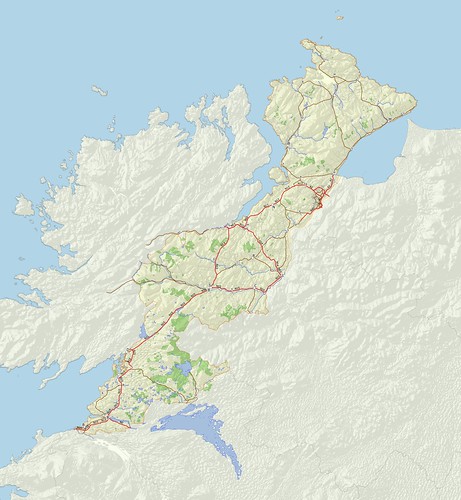
H34 West Donegal: Vice County raster map suitable for MapMate
Source data: (c) OpenStreetMap contributors; hill shading NASA SRTM via viewfinderpanoramas.com

One of the things I'd always planned to do once I had a half decent data set for the Irish Vice Counties was to create detailed raster maps for each of them. This is mainly because I've found using such raster maps useful for my own biological recording using MapMate software. They make choosing the correct recording location much easier, and reduce the hassle in producing more attractive (and communicative) outputs. I've detailed the principles behind the creation of such maps here in the past.

With the first such map I produced I struggled to get it to align properly with the Irish Grid displayed with MapMate. I could upload MapInfo .MIF files which would align, but these offered nothing like the degree of detail I want to show. Furthermore the import process with my copy of MapMate only seems to work with polygons. I tried a variety of ways: mainly trying to tweak the .TAB file format which I'd used successfully with files for Great Britain.So I put the idea to one side.

Very recently, prompted by Julia Nunn, VC recorder for County Down, I re-looked at the problem. Once again I was getting nowhere and  I was on the verge of seeking expert help from Richard Cantwell on the arcana of MapInfo's formats, many of which date back to the 1980s. (Richard works professionally with MapInfo data a lot and has written some very informative articles available from his firm's website.)

Note.  Much of this post will mainly be of interest to users of MapMate. However, towards the end I digress into geonerd territory when discussing the pros and cons of MapMate's technical choices about projections. Also please note that has been sitting in my draft folder for a while before being published.


Sunday, 14 February 2016

Distribution of Contributions in Volunteer-generated Datasets : Gall or Fruit Fly Records

I remarked in my OpenCageData interview that I see many similarities between biological recording and OpenStreetMap contributions. Indeed, I've had some interesting discussions about this with Prof. Muki Hakaly at UCL. Muki's group now do extensive research across the gamut of activities which fall under the rubric of "citizen science", so I'm hopeful that they will elucidate which features are common across this spectrum.

Chaetorellia jaceae f : 5532b
A female Chaetoraellia jaceae, a tephritid fly whose larvae feed on Knapweed.
Photo: (c) mausboam, Flickr.
Basically, we know that there is a very long tail of smaller contributions to OpenStreetMap. Both Harry Wood and Frederick Ramm gave presentations on aspects of this at SotM-14 in Buenos Aires, and Richard Fairhurst also touched on this at SotM-US in 2013. Very recently Marc Zoutendijk has used data collected by Pascal Neis to examine a cohort of new Dutch OpenStreetMap contributors from 2014 and 2015.

The usual hope expressed by people doing this type of analysis with OSM data is that by better understanding of these contributions we can improve the number of people who continue to contribute after the initial sign-up and first edit.

My perspective is slightly different, because it is coloured by knowledge of the much longer history of biological recording.


Friday, 16 October 2015

Irish Vice Counties : the creation of a specific dataset on OpenStreetMap

I've been meaning to write about OpenStreetMap Ireland's townland mapping project for some time.

It's a wonderful example of how historical maps are of significant value in creating really useful data on OpenStreetMap which is just as relevant as it today as was in the past.

The immediate reason for writing about them is that I have been creating vice county boundaries for Ireland. In doing so I have not just been using the data, but the fantastic range of resources made available through the activities of the townlands project.

Irish vice counties ex osm multicolour
The Vice Counties of Ireland
My first complete draft of the boundaries on OpenStreetMap