Showing posts with label skiiing. Show all posts

Monday, 23 December 2013

Mapping off-piste ski routes

The tragic death of a 16 year-old boy in Lech on Wednesday (18th December 2013), prompted me to look at aerial photos and various maps of the Arlberg area. As is usual with news reports of such accidents the information on the precise locality is fairly sketchy. This is always annoying to anyone who knows an area, and particularly if one goes off the marked pistes, because detailed knowledge of the route and conditions are essential to understanding the news. (Compare this with the volume of knowledgeable and detailed commentary on cycling deaths in London).

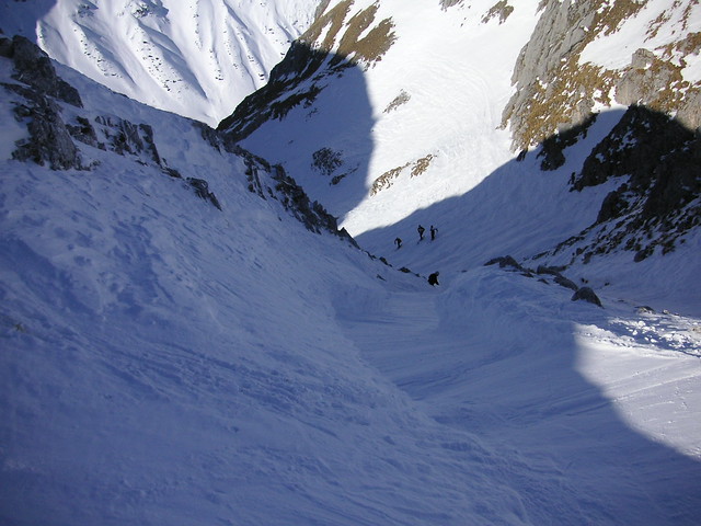
The boy was skiing with his father and his twin brother and a local ski guide. They started an avalanche which carried one of the boys, his father and the guide down the mountain around 150 metres. Fortunately the local news (understandably) provided a bit more detail: "Bereich Madloch-Fauler Stock Richtung Stierlochbach" and a photo of the avalanche.


The area NW of Madlochjoch on OpenSnowMap (View Larger Map)
(close the overlay to see the map)

The whole Arlberg area is well-known for a plethora of named off-piste ski routes, to quote "... every variant, however rarely skiable has a name...", so there was a good chance that this accident happened on a well-known run: particularly as it was so early in the season. As the avalanche debris fan was next to some Pinus mugo scrub the number of locations could be reduced. I own two books on Arlberg off-piste routes, but neither was to hand. I did find this fine photo with the main itineraries marked:

Overview of off piste routes accessible from Madlochjoch
((c)
Author: Roland Wasmayer, Source: freeskiers.net via OutdoorActive)
Details of the accident will be released by the Vorarlberg Avalanche service. These short accounts usually have an aerial photo giving an overview of the accident site, such as this one which was very wdely reported because it left a Dutch Prince in a coma from which he never recovered..

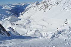
I mapped a little bit of the scrub on OpenStreetMap and also found this image of the entry to the Stierfall route. I suspect the the accident happened in either Heuwet or Heuwetrinne: both so frequently skied in mid-season to be heavily mogulled. None of these itineraries are mapped on OpenStreetMap, as is true for other itineraries throughout the Arlberg ski area.

Strengen 053
Entering the Stierfall, photo Stegaku
In April 1992 I was lucky enough to have great weather in St Anton after an exceptional snowfall in March. Conditions meant that there was wonderful spring snow for a couple of hours in the morning, but everywhere routes which are rarely skiable were fully covered. It was astonishing to see ski tracks in the most unexpected places: particularly on the W side of the Arlberg pass between St Christoph and Stuben. Many of these routes were skiied long before mechanical uplift existed: nowadays the position of ski lifts determines which are favoured.

One of the odd things about this is to discover long vanished ski lifts. A post on Edward Tufte's forum alerted me to a website featuring Heinrich Berann's ski maps and panoramas. (Berann may be familiar to others as the illustrator / cartographer of Ocean Floor maps). Berann's style is very recognisable. 


Ski map of St Anton-am-Arlberg by Prof H.C. Brann

What is particularly interesting is that he made ski 'maps' for the Arlberg area from 1937 through to the late 1970s, and therefore it is possible to trace some of the evolution of the area's infrastructure. Most noticeable is that until around 1980 there was a lift on the W side of the Arlberg road at St Christoph. Also noticeable is the curious way the grading of ski runs has changed: particularly true of runs now classed as freeride. Runs which were once just graded as black turned into ski itineraries, and some have just disappeared.

Of course someone has thought of mapping freeride territory: Freeridemaps of Altstätten, Switzerland. The sample image on their website is the Arlberg area around St Anton-am-Arlberg. In the main the map shows areas appropriateness for different ranges of skill and experience: but as far as I can tell largely based on objective factors, such as safety of run-outs, and likely consequences of a fall. Above all it is based on the steepness of the land.

The Swiss and Austrian avalanche service also produce map overlays based on steepness to show avalanche risk: in the Swiss case this data is available by subscription in the White Risk app for Android and the iPhone.

Mapping avalanche risk on it's own is a challenge. There are numerous different factors to represent: altitude, age and depth of snow pack, recent changes to snow pack, aspect, underlying terrain (steep grass slopes often avalanche). In writing this post I came across some interesting papers on the subject of the cartography of avalanche maps.

Profile of Snowpack derived using DAVOS ELF SNOWPACK program
One of the more intriguing ideas is how the history of the snowpack at a point can be displayed (see above). Quite how such data might be transformed to convey information on a map is beyond me.

Despite the great advances made in the past year with OpenSnowMap there is considerably more which we could do to provide information relevant to freeride and back-country skiing, and ski mountaineering.
  • Grading. In my view the current use of a single category of freeride downhill routes is misleading, Many off-piste guides such as those for the major French resorts published by Editions Vamos, or the similar Polvere Rosa covering the south side of the Monte Rosa massif, make use of grading schemes (4 classes of technical difficult in the former, 7 in the latter which includes some extreme itineraries; and 4 classes of objective dangers). I am hesitant to mark freeride areas which I know because of the wide range of difficulties and objective dangers likely to be encountered.
  • Routes. To a certain extent showing routes spoils some of the key aspects of being away from the piste. Picking ones own line, both in the light of one's ability and safety of surroundings is part and parcel of developing the skills and awareness necessary. In many places (Albona at Stuben, most of Les Grands Montets below 2800m, Pavi in A-basin) all that is needed is to show that the area is free-ride territory. In others entry lines and exit routes may not be immediately obvious and are worth showing (it is not uncommon for these to be the least pleasant part of a route), particularly if there are cliffs or other hazards lower down (e.g., above Le Fornet, Val d'Isere).

    Seracs_1779
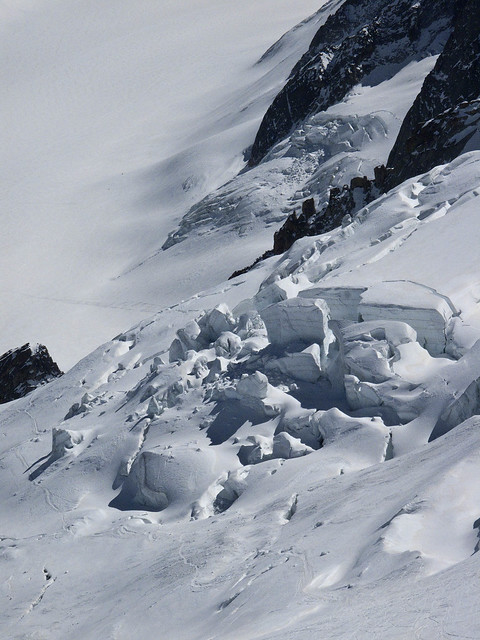
    Seracs on Glacier des Rognons, Les Grand Montets by LensScaper, on Flickr
    IGN Geoportail shows what's underneath the snow.


  • Objective Hazards. If more freeride terrain is to be added to OpenStreetMap there needs to be much more mapping of the obvious objective hazards: cliffs as mentioned above are the prime example. Others might include: streams (which may not be frozen enough to bear loads), known crevasse and serac fields (mapping individual crevasses can wait a while), 'bullet-proof' ice on glaciers, and notorious avalanche gullies.
  • Safety. Obviously marking ski routes creates some concerns over people placing too much reliance on such information. In reality people undertaking such routes require a minimum level of skill, equipment, knowledge and experience.
Freeride and backcountry skiers need a sizeable amount of cartographic information: some is persistent, much of it is transient. The ability to convey this data in suitable maps is a significant and interesting challenge. The flexibility of OSM data and technologies suggest to me that we can play a role. However, we need much more base data: in particular GPS traces, and good perspective photos of routes with suitable open licenses.
Note: This post contains a number of images which are copyright by their respective authors, and are not licensed under creative commons. Normally I try and only use CC images, but in this case suitable images were not available. Please respect the rights of the image owners.

Friday, 10 June 2011

Hyperlocal Naming

Stanage Edge from Stanage Plantation
Stanage Edge, Derbyshire
The site of hundreds of hyperlocal names used by rock climbers.
Photo courtesy of Earthwatcher BY-NC-ND

We had an interesting a discussion in March on the OpenStreetMap talk-gb mailing list arising out of some controversial naming practices in Loch Lomond and Trossachs National Park ("Giro Bay"). Someone suggested that no-one would or should ever add newly minted names on OSM.

This is an extended version of why I think that names widely recognised in specialist communities should be used when appropriate. I call these names "hyperlocal", because many of them are used for naming features or localities which non-members of the relevant community would not recognise, or would see no need for naming them.

Naturalists. This whole post started because someone expressed surprise that 'non-official' names might be entered in OpenStreetMap (all my examples are from Attenborough Nature Reserve, Nottinghamshire). Naturalists, and particularly those managing and using nature reserves, are creating new names all the time. In part this is because often these places themselves are new (for instance old industrial workings and quarries — "The Delta", "The Bund"), but mainly because much greater precision is required for location information. This is really important if one wants to find the only example of a rare plant, or check on a bird-box location, or photograph a rare fungus, or make sure the right tree gets chopped down. Also one becomes increasingly aware of minor differences which dramatically affect the range of plants and animals over a small area. In principle this could be communicated by using grid references and at a fine scale a GPS. In practice names are more memorable, help to delineate areas which grids don't, and are much easier to communicate. Some names stick, others may be concocted but never enter common usage. Some places have multiple names, and it takes a long time to find a consensus ("Old Car Park", "Fishermans Car Park", "Education Meadow", "Corbett's Meadow"). Many names have multiple intelligible variants ("Butterflies", "Butterfly Triangle", "Butterfly Patch"). In other cases it's possible to see how a name changes. For several years charcoal has been made at Attenborough: the area by the kiln is now nearly always referred to as "by the Kiln", whereas it used to be called "Redwings". In other places locations are known by number alone, for instance 'compartment 73'. I have a map of compartment numbers for Clumber Park, but it's an internal National Trust document, they are used in the national Fungal Records database though.

I have added several of these 'made-up' names which are in common usage around Attenborough Nature Reserve: the Delta, Warbler Dell, Dirty Island Bank, Butterfly Patch (in use since the 1960's), Corbett's Meadow (a recent 'official' coinage, in memory of Keith Corbett who was reserve manager for over 30 years until his death in 2007), which is also known locally as "The Fisherman's Car Park", and "The Old Car Park", and Education Wood (a recent unofficial coinage, around 2005). As all the water bodies were created by gravel working, their names have evolved recently too. I have only added those which are in widespread usage: there are perhaps 50-odd names which were coined in the '60s and '70s, mostly eponymic toponyms, but many never caught on.

Carsington Reservoir is another location where local birders have evolved a significant number of toponyms. Any of the Helm "Where to Watch Birds" regional guides will provide many more examples.

Climbers. Hill and mountain areas are chock full of named features which might never be noticed. This isn't surprising, the cliff shown at the top of this post Stanage Edge has 100s of climbs along its length. The convention is that the first people to successfully climb a route have naming rights, but it's more complicated than that. An even smaller crag further S in Derbyshire, Birchen Edge, has a convention that climbs names should have a nautical allusion (Trafalgar Wall, Camperdown Crawl). I would think in Derbyshire alone there are probably well over 5000 named climbing routes. Many of these will be less than 20 m ascent. On the harder ones each hold will be memorable (I'm not yet aware of these being named yet). On the other hand some places fall into disuse. My father and his friends used to climb at Laddow Rocks because it was accessible by bus from the Manchester area. Much of Laddow is now mossy and green, but everything on it still has a name: several guidebooks were published.

Oddly, in bigger mountains such as the Alps there is not this degree of minutiae in naming: or if it exists it's not published so widely. A number of factors influence this. Climbing in the Alps tends to follow obvious lines because there are a lot more of them, and they're much longer. Sport climbing has used pictorial 'topos' for a long time, so they avoid the same need for names as a narrative descriptive system. There are still plenty of these names though, the Eiger Nordwand has lots, all used in many mountaineering books, and giving a title to one: Hinterstossier Traverse, The White Spider, the Third Ice Field, Traverse of the Gods, Exit Cracks and so on. That is just one face of one mountain, albeit a famous one, and there's enough variety in the type of names to give a feel for how they were created.

Skiers are another group who go into the mountains for recreation. In many ski resorts many of the names are invented and often follow a stereotyped pattern typically with lots of alpine fauna: White Hares, Pika, Marmots, Chamois, Ibex, Ptarmigan. The older European resorts still use lots of names which arose naturally from older uses.

St Anton - Ulmerh¨tte from SchindlergratSt Anton in the Tirol has many ski runs and locations named after alpine meadows. Some of these, such as Gampen (often Gampli) have an interesting linguistic history indicating the presence of speakers of a latin-derived language in the area similar to modern Romansch. Mattun, is another name ultimately derived from latin, referring to a characterstic member of the mountain vegetation. Both of these are fairly common place name elements close by in the Eastern Graubünden. (Place name etymology from the Swiss Alpine Club guides). In addition to the regular runs, St. Anton has a host of well-known, named, off-piste runs. The photo shows the top of a broad but steep gully off the Schindlerspitze: but, I never learnt the names of these gullies. Some of the seriously steep chutes have names which are closely guarded secrets passed on only to those who have skiied them.

Photo courtesy of rickardengstrom CC BY-NC-SA

On the Grands Montets many apparently non-obvious features have names (often different names in different languages): Combe des Amethystes or the Italian Bowl; Canadian Bowl. Again these are not to be found on maps, but are widely used by people who know the area. One or two specialised publications use them too. It's possible to ski a line a few metres from the Italian Bowl and not be aware that its there: even then finding the direct entry which gives an exhilarating steep start requires precise knowledge of the local geography. So once again, these names have arisen from a need for much greater precision than might otherwise be expected.

Ski racing requires a heightened awareness of terrain which again tends to drive increasing precision in naming. One of the oldest open downhill races in the Alps is the Parsenn Derby. When I first visited Davos the piste which formed the lower part of the course had markers giving the names of each turn and schuss. nowadays the course is shorter still, but still features places like the 'S-bends' and the 'Derby Schuss'. It's not for wimps like me:


Motor Racing. Any one who has followed a Grand Prix will know that every part of the track has a name. Of course on a modern track these names will have been invented and assigned by marketeers, but on courses with a long history, like Silverstone, it's easy to guess how the names came about. Early users probably said things like 'I came off at the corner near Stowe', which being cumbersome would get rapidly shortened to Stowe Corner. Of course names were useful to everyone: drivers, instructors, marshals, commentators and spectators. Now they integral to what people expect of a motor racing track. Many of these are captured on OSM, including the circuit featured on Top Gear.


Fishing. I know little about fishing, but it struck me that fishermen must have names for favourite spots, and then I came across the wonderful annotations of Walking Papers by Kirk Lombard. The one I show above is near Fishermans Wharf, San Francisco, with one fisherman's name "Striped Perch Hole". Incidentally, this seems to be a great example of using Walking Papers (and OSM) in an innovative and unexpected way.

Names seem to evolve in each of this situations in similar ways. Often they are created by pragmatic shortening of a description. Memorable events, and the people associated with them, are another rich source of names. Things also get named after people as a token of appreciation, respect or a with to remember them. Thematic naming sometimes works, but often ends up being insufferably twee, and is often resisted or subverted, particularly by wit.

One last one example are local names to the swimming holes on Fairham Brook by Keyworth Meadow NR: see Neil Pinder's article on the parish website. I've asked around for other examples, and someone with extensive experience of forestry noted that workers named landscape features in a very similar way to naturalists I'd be very interested to hear of other examples, particularly outside the interest domains I've covered in this post.

The ability to map these hyper-local toponyms is a very attractive part of OSM. Of course, they need to be researched accurately to ensure they are names which are used rather than 'book-names'.