An inevitable problem arises when mapping in Britain these days. How does one map dead pubs?
Pubs have been dying at an increasing tempo ever since the
Beer Orders of 1989. Some of this is due to the rapacity of the 'pubcos', but much is due to cheap supermarket booze, social change in inner-city areas, and a broader range of alternative means of entertainment. Although dead pubs exist everywhere, it's the ones in inner-city areas, or suburban estates, which I notice most frequently.
Some pubs are 'zombies', having fallen into a 'close-reopen-fail-close' cycle (phrase nicked from
Richard on IRC). These can often be identified by the 'run your own pub' banners outside. There are also pubs which are only slightly more alive: often remarkably difficult to work out their actual status when walking past during the day. Just occasionally one of this class of pub gets resurrected. I tend to tag all such pubs as ordinary pubs, but if currently closed will add "(closed)" after the name. I do this for two reasons: an amazing number do show a triumph of hope over experience, and re-open; and, secondly, pubs are important navigational landmarks.
The Target roundabout at
Northolt on the A40 is a good example of the latter, even though the pub closed in 1986 when it was converted to a burger bar.
Once the pub sign has gone and all the windows are boarded up then I'm willing to accordingly change the tagging to
amenity=dead_pub or similar. Usually such pubs either change use, or get demolished. Local to Nottingham they've turned into supermarkets (two Tesco Express stores : the
Jolly Higglers,
17/21st Lancers), Indian restaurants (The Poachers Tavern now the
Gurkha Kitchen) and mosques (
Le Grand, Hyson Green , and possibly
The Boulevard). The A610, Nuthall Road, has a large number of recently demolished pubs, typically they are replaced by housing. Other recent housing developments include : Cremorne Drive is a private gated road in The Meadows on
the site of the Cremorne Hotel; Beaumont Square has been built on the
site of The Wollaton Arms.
Elsewhere, the Stonor Arms in
Stonor has been closed since the early 2000s, and despite recentish
press coverage didn't look likely to open again last summer, but
The Robin Hood in Pinkneys Green sprang into life again in 2007 after being boarded-up for 6 years. So its remarkably difficult to be certain about dead pubs.
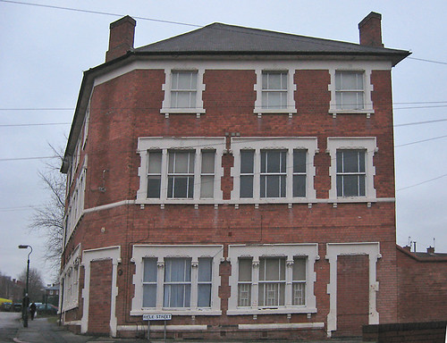
A very few remain intact as buildings but with a changed use, like
The Dover Castle (photo above), now let as student accommodation. I don't know when this closed, but it was already there by the time of the
1891 census. Familiarity with an area, or close inspection of the building will reveal the former use: then it's worth recording them as
building=pub.
P.S. Chris Richards (riffdesign) has some nice atmospheric
photos of Radford between '70s and early 90s, including several dead pubs.

.jpg)