There are two obvious questions that can be asked using street light data:
- How well mapped are all public highways (i.e., including footways and cycleways) in the city?
- Are the highways on OSM accurately mapped?
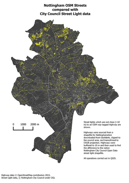
It is trivial to buffer the network of highways from OSM (via a Geofabrik download) and then use geometry operators to find all lights within the highway buffer envelope, and all outside the envelope. Using a very simple constant buffer of 10 metres I obtained the following result:
 | ||
| Street lights which are not close to OSM roads (best viewed large). |
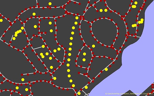
The most immediately noticeable thing on this map is that some areas have a much denser pattern of 'misaligned' lamp posts. In particular there are several areas in the far north of the city: these are all social housing developments dating mainly from the 1970s and 1980s. Although there are relatively few missing streets, there are many (named) footways in these developments which are missing. In addition many of these areas have not been received a field survey so this type of feature is missing. Even in other similar areas of the city (to the S and E of the City Centre) which have been surveyed there are still many missing paths, at least in part because the path network is very dense and difficult to survey. In the main this information corroborates what I already know about which areas of the city require more detailed surveys.
 |
| part of Rise Park Estate, Nottingham showing missing footways on the basis of street lights not aligned with OSM data (yellow), remaining lights are shown in maroon |
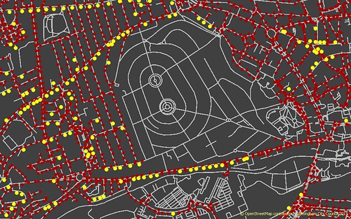
A second. aspect is accuracy. Many streets have 'misaligned' street lights on their S side. This is most obvious with streets which are oriented E-W. I have a pretty good idea that this is because the streets are indeed misaligned, most probably because they were traced from Yahoo imagery long ago and the alignment has not been corrected since. (And for good reasons, realigning data and keeping the topological relationships right requires a lot of care).
 |
| Potential mis-alignment of OSM highways in Wollaton and Bilborough areas of Nottingham (coloured blobs are street lights as above) |
Thirdly, we can find missing highways. The example below is particularly clear because it shows a cycleway through a park.
 |
| Missing foopath/cycleway at Sandy Banks Local Nature Reserve, Nottingham (the path has been partly mapped since from Bing imagery, a survey is required to check if it can be used by cycles ) |
One last point, is that one can also find areas of land which are private (some are well known, such as The Park shown below, which is all lit by gas), but I've noticed one or two new developments with no council owned street lights. (I know the dataset is up-to-date because it includes the positions of new lights on our road installed in the Autumn).
 |
| The Park, Nottingham, showing absence of council-owned lighting. |
At some stage I'll work a bit harder to see if I can quantify any misalignment factors. I'd also like to see how feasible it is to re-create the road network just from the position of street lights!
Once again the principle message is that this is another data source which can be used to validate, check and improve OSM. It's particular value is in identifying where we have failed to map footways and cycleways: I am not aware of any other (open or public) dataset which enables such a comparison.
Which Park in Nottm is lit by gas lamps ?
ReplyDeletePaul, it's not a park that is being referred to, but a private estate named "The Park". http://en.wikipedia.org/wiki/The_Park_Estate
ReplyDeleteWhen I was in Nottingham, I tried to use this map to navigate to some missing roads. Sadly I was on my phone not a computer at the crucial moment so it was hard to use. The map could do with some context or zoomed in a bit more.
I wonder if round Mapperly it's service roads, such as car parks that are missing. I'm adding some as a result of my survey of the high street.