Showing posts with label Addresses. Show all posts

Friday, 5 June 2020

Housing Terraces in Wales : a minor addressing conundrum

Two terraces of housing off the Holyhead Road (former A5) in Llanfair PG.
Penucheldre and (to the right Britannia) Terrrace. A typical type of housing throughout Wales, they provoke some addressing conundrums.


In May 2015 I attended the funeral of a relative in the Anglesey village of Llanfairpwllgywngyll (usually referred to as Llanfairpwll or Llanfair PG, but perhaps better known for having an extremely silly long form of the name). This is the ancestral village of my maternal great-grandfather: the funeral marked the end of around 150 years of members of the family living in the same house that he grew up in.

I know the house well. As a small child I visited frequently. It was only a short excursion by bus from Bangor, where we lived. My mother knew it much better: in the early part of WWII she and her grandmother lived here with my great-grandfather's sister. Even when I was small the village was not very large. When my mother was a girl there was much open land between the old part of the village (Pentre Uchaf) and the newer part (Pentre Isaf) next to the railway and main road to Holyhead. By the late 1970s the village had grown immeasurably with lots of overspill suburban housing for Bangor.

The big change between 1939 and the end of the '70s was that streets started to be named and houses numbered along the street. Prior to that building development had been piecemeal: most usually a mix of individual houses and most typical of many parts of Wales: named terraces. By this I mean short terraces of houses where the terrace rather than the closest street provides the name used in the address. Elsewhere there are plenty of terraced houses where individual terraces have names (often shown on a carved stone set into the brickwork of the terrace), but the numbering of houses solely relates to the street.

Thursday, 18 September 2014

OpenStreetMap at the UK Open Addresses Sympoosium

I attended the Open Addresses Symposium organised by Jeni Tennison of the Open Data Institute last month. This brought together a host of people and organisations interested in having an open alternative to the Postcode Address File (PAF).

Somewhat foolishly I'd suggested to Harry Wood that I might speak about addresses on OpenStreetMap.

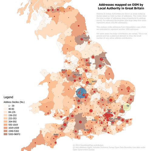
Addresses mapped on OpenStreetMap in Britain
Density of address mapping in (southern) Britain on OpenStreetMap by local authority
(Northern Scotland not shown because little data, full map)
See text on map for full explanation.
I was glad to see that my talk was relatively late on in the day: the audience were unfamiliar and many of them came from large organisations., so I appreciated the chance to get an impression of them.


Friday, 22 August 2014

WWII Bombs in Nottingham : discovering local history whilst mapping

Last Saturday I showed 2 visitors how I mapped addresses (more on this later).


Infill housing, St Cuthbert's Road, Nottingham NG3

One little vignette stood out.


Thursday, 22 August 2013

PfAFing About : opening UK address data


IMG_8283a
The Postcode Address File doesn't work all the time.
I recently mentioned that the Royal Mail's Postcode Address File (PAF) had elicited a lot of recent controversy. Well the controversy continues as the UK government has announced that the PAF business will be privatised along with the Royal Mail despite protests from some well-known people:

Naturally this has led to discussion on twitter as to whether one can create a fully open alternative to PAF.

The rest of this post is probably mainly of interest to mappers and OpenData advocates in the UK. To the outside world UK OpenStreetMappers seem to be oddly obsessed with postcodes. I hope some of the reasons for this may become apparent from this post.

Monday, 8 July 2013

June Nottingham OpenStreetMap Pub meet-up

A mix of late 19th/early 20th century terraced houses
on Foxhall Street, Forest Fields, Nottingham.
At the S end there are substantial villas near The Forest itself.

  After a hiatus of two years I decided it was time for another pub meet-up in Nottingham. 

We followed the formula from the past: an hour of mapping before adjourning to the pub. I've set dates for the next few months: the next meeting is on Tuesday 9th July.

Here's what we got up to in June. 

Thursday, 28 March 2013

Lamp Posts to Addresses: gold dust in the attributes

Local Government Open Data 4


I'm so used to a lot of open data being poorly attributed that I did not look at the Nottingham street light data until I'd imported it into PostGIS. Apart from lacking the asset identifier, and having redundant fields for the x and y positions of the geometry, it has two fields of fantastic value for enhancing OpenStreetMap.

Lenton Sands addresses
Lenton Sands area of Nottingham showing House Numbers from Lamp Post data overlaid on OSM