 | |
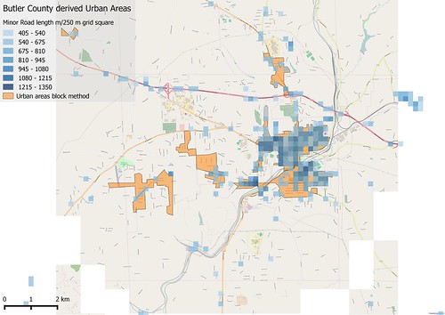
| Comparison of Urban Areas derived using "block method" and gridded road density. Only grid squares with over 500 m of road included. The area shown is around Butler, Butler Co, PA |
Showing posts with label road network. Show all posts
Showing posts with label road network. Show all posts
Sunday, 15 November 2015
Urban Areas 4 : Derivation from OpenStreetMap using road density
Another variation on the theme from the last post: this time looking for some measure of road density.
The easiest way is to sum road lengths in individual cells. The cells have to be quite small (say 250 metre square) to achieve the resolution desired. I've excluded link roads and motorway & trunk highway classed in this calculation.

Subscribe to:
Posts (Atom)

