Showing posts with label Postcode Address File. Show all posts

Thursday, 18 September 2014

OpenStreetMap at the UK Open Addresses Sympoosium

I attended the Open Addresses Symposium organised by Jeni Tennison of the Open Data Institute last month. This brought together a host of people and organisations interested in having an open alternative to the Postcode Address File (PAF).

Somewhat foolishly I'd suggested to Harry Wood that I might speak about addresses on OpenStreetMap.

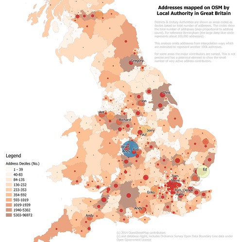
Addresses mapped on OpenStreetMap in Britain
Density of address mapping in (southern) Britain on OpenStreetMap by local authority
(Northern Scotland not shown because little data, full map)
See text on map for full explanation.
I was glad to see that my talk was relatively late on in the day: the audience were unfamiliar and many of them came from large organisations., so I appreciated the chance to get an impression of them.


Thursday, 22 August 2013

PfAFing About : opening UK address data


IMG_8283a
The Postcode Address File doesn't work all the time.
I recently mentioned that the Royal Mail's Postcode Address File (PAF) had elicited a lot of recent controversy. Well the controversy continues as the UK government has announced that the PAF business will be privatised along with the Royal Mail despite protests from some well-known people:

Naturally this has led to discussion on twitter as to whether one can create a fully open alternative to PAF.

The rest of this post is probably mainly of interest to mappers and OpenData advocates in the UK. To the outside world UK OpenStreetMappers seem to be oddly obsessed with postcodes. I hope some of the reasons for this may become apparent from this post.