Showing posts with label mapping. Show all posts

Thursday, 30 October 2014

War Memorials: revisiting an OpenStreetMap Project of the Week

Great Gable from Broad Crag col - geograph.org.uk - 768103
Great Gable, a mountain in the English Lake District.
The summit and around 1200 ha of the surrounding area are dedicated as a war memorial.

Four years ago I proposed mapping war memorials as the OpenStreetMap Project of the Week. It ran in early November 2010 to coincide with the anniversary of Armistice Day, when several countries honour their war dead. At the time I was intrigued at how this particular topic resonated with mappers.

I was gratified that both Peter Reed and Chris Hill felt engaged by the idea. Richard Weait, co-ordinator of Project of the Week, wrote a very interesting post about the poem "In Flanders Field" which was written by a Canadian.


Tuesday, 28 October 2014

Strava & OpenStreetMap GPS traces: a quick comparison

Strava introduced their heatmaps and their Strava Slide tool at the Washington DC conference of the OSM US community SotM-US in the spring. I had a quick look at the time and it seemed interesting, but there was little data in areas which I map.

A question came up recently regarding how accurate the Strava heatmaps are for mapping routes on OpenStreetMap, particularly in wooded areas. This prompted me to have another look at the data.

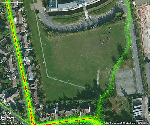
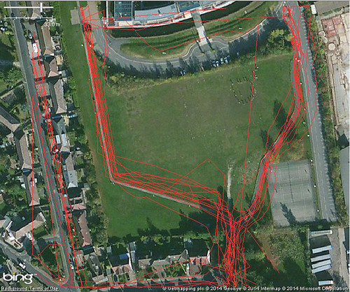
It happens that I have made a lot of traces across two paths on an open playing field (an area sufficiently unobstructed that it is used periodically for calibrating and testing professional grade GPS equipment). A short distance from these two paths is NCN 6, a heavily used national cycle route. It was therefore very easy to grab some screen grabs of Strava and OSM data:

Jubilee Campus, Nottingham : Strava Heatmap
Strava Cycling Heat Map
(NCN 6 on left, university cycle paths centre & right)

Jubilee Campus, Nottingham : OSM GPS traces
The same area showing traces which have been uploaded to OpenStreetMap
(probably mainly by me)


Thursday, 18 September 2014

OpenStreetMap at the UK Open Addresses Sympoosium

I attended the Open Addresses Symposium organised by Jeni Tennison of the Open Data Institute last month. This brought together a host of people and organisations interested in having an open alternative to the Postcode Address File (PAF).

Somewhat foolishly I'd suggested to Harry Wood that I might speak about addresses on OpenStreetMap.

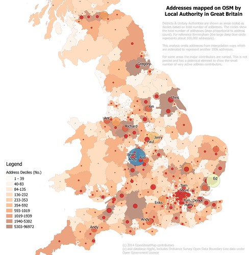
Addresses mapped on OpenStreetMap in Britain
Density of address mapping in (southern) Britain on OpenStreetMap by local authority
(Northern Scotland not shown because little data, full map)
See text on map for full explanation.
I was glad to see that my talk was relatively late on in the day: the audience were unfamiliar and many of them came from large organisations., so I appreciated the chance to get an impression of them.


Monday, 8 July 2013

June Nottingham OpenStreetMap Pub meet-up

A mix of late 19th/early 20th century terraced houses
on Foxhall Street, Forest Fields, Nottingham.
At the S end there are substantial villas near The Forest itself.

  After a hiatus of two years I decided it was time for another pub meet-up in Nottingham. 

We followed the formula from the past: an hour of mapping before adjourning to the pub. I've set dates for the next few months: the next meeting is on Tuesday 9th July.

Here's what we got up to in June. 

Wednesday, 5 June 2013

Vanishing Pubs

As I've surveyed shops in the past few weeks I've been completely amazed to see how many pubs have closed in the past 2-3 years. I wrote about mapping former pubs a couple of years ago.

Vernon Arms
The one that provided the initial idea for this post : Vernon Arms, now a Sainsbury's Local
This is a photographic selection of some I have encountered in Nottingham over the past few weeks, with a sprinkling of ones which closed long ago, but which I used to frequent. I've tried to be reasonably eclectic in my choice of pubs and their current uses, unfortunately I didn't realise that a Police Station was a former pub.


Monday, 20 June 2011

The Church which turned into a Gurdwara: pre-pub mapping

Church? 4827a

This is a very belated write-up of the May Nottingham pub meet-up.

First of all it was great to meet will_p, our most productive local mapper, and to welcome Paul the Archivist who has mapped actively in his home town Derby, Birmingham and Cardiff. A few of us met at the pub for an hour walk and a bit of light mapping: this is always a good opportunity to compare notes about how different people map and talk about specific issues as they arise (such as how does one represent the surface of the road below: we didn't have a good answer!).

surface=? 4804a

I find it difficult to think of an area comparable to that around the Lincolnshire Poacher which has a similar variety of different sorts of places within a couple of hundred metres: modern social housing, schools, a university campus, retail and commercial areas, pre 20th century housing, large houses, parks, gardens etc. It's also not that well-mapped, something which only really becomes apparent by walking through and checking OSM with what's on the ground. In fact our little mapping walk showed, once again, how much can be missed when one only uses aerial imagery.

We again chased down a few missing road names, but failed to see any signs on one road. Marcus pointed out a few streets along Woodthorpe Road which were blocked and not mapped properly (these are tree-lined so guessing that they connected from aerial imagery was wrong).

This time we headed into the S edge of Mapperley Park, one of the wealthier parts of the city, and a great contrast from St Anns, just the other side of the ridge line. We only followed three or four roads but it was very clear that the original sources of OSM data were pretty poor: this was a mix of NPE maps and aerial imagery. Density of mature trees in Mapperley Park made it difficult to identify the actual road lines from aerial imagery. We walked down Redcliffe Road the upper parts deeply cut into the rock and supported by Bulwell Stone walls . These stone walls area a classic sign locally of a private development between about 1880 and 1960. After 1960 the quarries were running short of this attractive Magnesian Limestone. Many are now used for housing or industry close to Bulwell town centre.

Old Boundary Marker : 4802aThe most interesting site along this road were a couple of cast-iron boundary markers from 1859: these list the mayor and town clerk of the Town of Nottingham (it didn't become a city until some time later). In style they are very similar to the markers used when the City boundaries were extended in the 1930s (see an earlier post). I was intrigued because I didn't know which area was on the other side of the boundary. Fortunately we have an old map at home (Salmon's map) which is virtually contemporaneous with these boundary markers. I took a couple of pictures of the same area that we walked through showing the state of Nottingham in the early 1860s. This clearly shows the boundary, and that Mapperley Park and much of the Forest were in the parish of Basford. Basford was incorporated into Nottingham in the 1880s.

Nottingham boundary 1861 : 4947b

Also of interest is that the road was then called Red Hill Lane. Some road names in St Anns have been preserved although in altered form after re-development, but quite a few on the roads around Bellevue Reservoir seem to have been lost. It's not clear what name the paths round the reservoir have themselves: this old map calls it St. Anns Hill, which now belongs to a road which was then called Blenheim Villas, whereas modern maps (and some from the 1930s) name it as part of Corporation Oaks.

Gurdwara Noticeboard: 4832a

Returning to the pub along Mansfield Road we had a better look at the prominent church shown at the top of the blog. Paul had noted that it seemed to be a Gurdwara, a Sikh Temple, and as we passed it took a 'photo of the notice board. The following day I felt compelled to do a bit of research: How long had it been a Gurdwara? Who built it? what was it's recent history? I was relieved to discover that it had recently been acquired from the Christian Scientists who have moved their place of worship into their fine office building next door. But originally it was built as a Presbyterian church. So it had been a church when first mapped on OSM, but another object lesson that things ain't what they seem and the importance of ground surveys.

OSMers in the snug :4837a

We ended up in the snug at the Poacher for a pie (Paul) and several pints.

Sunday, 15 May 2011

Access Land

Snowdon from Moel Eilio : 3351a

Snowdon has experienced flurry of edits on OpenStreetMap after the last two long weekends. I happen to be one of the culprits as I've been adding some detail from last July: not least because a family member is planning an attempt on the Welsh 3000ers next month.

The availability of Bing aerial imagery allows a lot more detail to be added, particularly when I can relate it to geotagged photos. I've been able to add:
  • walls and fences alongside or crossing tracks;
  • bits of marshy ground;
  • extend paths which I saw, but didn't walk;
  • and, correct alignment of streams and rivers.
In doing so I've also noticed quite a few things which I recorded but had not transferred to OSM: notably stiles and gates.

Access Land roundel : 2684bWhilst looking at these photos I noticed one of a stile had a roundel indicating the start of Access Land. I've suggested before that it's worth mapping these locations as the complete area covered by access land is only likely to be worked out through gradual accumulation of access points. However, when push comes to shove, I'd not done it myself and couldn't think of an obvious tag for it.

Top of Glyn Rhonwy Acces Land : 9225aI also found a photo of a large notice for the area, Glyn Rhonwy. This contains a lot of old slate quarries including one huge hole. The notice states that the upper part of the area is access land. However the stile we went over when we came out of the old quarry area had a rather threatening warning notice. This appears from the Ordnance Survey mapping to be exactly where the Access Land starts.

Bottom of Glyn Rhonwy Acces Land : 9187aThere was another puzzle on the edge of Llanberis. We wanted to avoid walking straight down the road, so had aimed for a footpath marked on the map leaving at a corner of the road above the tea shop at Penceunant Isaf. Checking the OS map today I see that this is also Access Land. All we found was a firmly locked gate.

All in all the Access Land areas in Snowdownia are not that well marked, and are often huge: making them poor targets for mapping. In most cases they're fairly obvious, or are areas where access has been presumed for many years, so adding them to OSM is not a huge help for the walker. Closer to towns and villages there still seems to be plenty of ambiguity. I'm not a fan of the huge intrusive notices that do exist either. They seem inappropriate in a National Park.

Although I added a lot of detail in Snowdoia, I needed to find somewhere else to look at mapping Access Land.

Chrome Hill : 2633a

The one place I have been in the past couple of years which is access land and where I probably have enough information to map access land is Parkhouse Hill. This striking little hill, one of a pair of fossil coral reefs (the other, Chrome Hill is shown above), lies just inside Derbyshire in the upper reaches of the valley of the Dove. It is also one of the places which was pretty inaccessible until Access Land was introduced by the 2000 CRoW act.

View N from Parkhouse HIll : 2666a

I took a whole series of photo from the ridge of the hill in September 2009, but without good aerial imagery it was not possible to delineate the outline of the accessible area. Only when writing this post did it occur to me that I could now complete this mapping. Accordingly, I've mapped the access land itself as a relation, and added the tag entrance=access_land where I recorded the relevant sign. The tagging is still pretty tentative, but I hope having something concrete will lead to a common approach.

Monday, 9 May 2011

Catmose Campus : an Oakham update

IMG_4429a
On the way back from Barnack I diverted from the Oakham ring road to go and check how much of the Catmose Campus was open. I mapped this a few days before its scheduled opening in February, so it was good to have a simple quick mapping objective.

catmose_campus_merge_4422e

It proved that my quick photos taken in the rain were not a very good guide to the actual location of the building (compare with the actual GPS traces in this screen snapshot):

Catmose Campus in Potlatch2


As I walked up to the entrance to the Sports Centre I reflected that at some stage most mapping should become like this. A short stop off to grab the new details of the changed area, and a quick and simple edit session to finish off. We're a long way from that point, but before we get there we'll need better ways to identify areas with changes and to manage checking their status.

All-in-all a more satisfying mapping experience than last time I was in Oakham: the weather was nicer too.

Saturday, 7 May 2011

Along the Fosse Way: mapping a new road


The A46 between Widmerpool and Farndon (near Newark) is being reconstructed as a dual carriageway and is due to open next year.

Kev Swindells has done a great job mapping the southern section of these road works to the junction with the A6097 at East Bridgford. Several sections are already in use, and once again OpenStreetMap is more up-to-date than other online maps. The most obvious of these is the big new roundabout West of Bingham (below, also compare with Google Maps).


At our first pub meetup in Nottingham I asked Kev he was going to do any mapping North of East Bridgford, but apparently its beyond his normal bike runs. I'd already taken some audio notes last summer and had marked in a new overbridge near Elston. So on a nice spring evening I decided to see how much information I could collect for the remaining part of the route. I tried to cross the line of the road works on as many minor roads as I could, starting from Newark and working my way back towards East Bridgford.

IMG_3569a

Even with decent waypoints for the crossings it's not straightforward to get the rest of the alignment. Several things do help:
  • Powerlines. Lots of powerlines cross the Trent S of Farndon, and all have been mapped (from surveys, Bing and OS OpenData). From photos I can check how the road alignment compares to pylon positions.
  • Field Boundaries. Most field boundaries visible on Bing are still there: obviously they've gone along the construction zone, but again it's useful information.
  • Hedgerow Trees. The farmland on the E side of the Fosse Way towards the River Devon has little in the way of trees and no patches of woodland. Each large tree which can be located on a photo can be matched to the Bing imagery.
  • Aerial Photography. In a couple of places the Bing imagery is recent enough to be able to see that the ground has been cleared in preparation for construction. This was particularly useful just N of Flintham close to the point when the new road crosses the old road (nothing on the ground yet: presumably this will be the last phase of construction.
This mapping is very preliminary: Kev mapped the Southern section in multiple visits by noting where the roadworks obstructed cycleroutes. Ideally more of the local minor roads and footpaths could be mapped to add to the detail as the road nears completion. This is particularly true near East Bridgford. The precise location of the two carriageways is also not clear: round RAF Syerston it looks as if the cutting is not completely excavated yet.

All Saints Syerston : 3581aAll Saints Hawton : 3535a

I didn't forget to collect other data: the little village of Syerston was missing all its roads. It has a nice little church too. I was able to do a bit of general tidying up of the other minor roads. Another nice church, which was already mapped is at Hawton: this has a very fine Easter Sepulchre in the chancel. Both churches are dedicated to All Saints.

Friday, 29 April 2011

Leafy St Ann's : pre-pub mapping

Mini-mapping party: 3092a

Despite it being just after Easter and the date being announced with only a weeks notice, there were 6 of us at the second OSM pub meet-up. This time we met at the Lincolnshire Poacher on Mansfield Road: definitely a pub worth of the real_ale=yes tag.

With lighter evenings it seemed worth doing a bit of mapping before having a drink: also a good opportunity to show people the ropes. I chose the Poacher, not just because its a nice pub with good beer, but because there are quite a few places in the immediate vicinity which could do with more map survey work. These include the Arboretum, Church Cemetery, also known as the Rock Cemetery and residential areas either side of Mansfield Road.

I'd done a bit of preparation for each of these, but once I realised that there'd be enough of us I persuaded people to visit St Ann's. Although this inner city area has a poor reputation I knew a decent route, and it offered a much more varied insight into the issues associated with collecting data for OSM.


The main mapping objective in this area was to fix roads with missing or, possibly, incorrect names. I had made a print out (see above, and here registration required) from ITO OSM Analysis which provided the basis of a reasonable hours mapping. We walked a loop down behind Huntingdon Street, along St Ann's Well Road and then along the tree-lined walks of Robin Hood Chase, Corporation Oaks, and Elm Walk back to the pub.

IMG_3090aSt. Ann's is predominantly 1970s and early 1980s social housing: the area having been re-developed as part of a slum clearance programme. It was planned with a 'Radburn' layout : lots of cul-de-sacs and interconnecting walkways. Addressing and street names are really confusing as we immediately found out. We walked through a twitchell from Huntingdon Road and found houses with addresses on Sherwin Walk, but we were looking for Sherwin Close. On the opposite side of the road were houses on Welbeck Walk, with Welbeck Close already mapped on OSM. This seems to be typical throughout the area: house addresses are slightly different from the streetname. In addition there are groups of houses which have a separate address, but no linked street: Rodel Court was one I noticed as we crossed Abbotsford Drive.

Open Space, Instow Rise : 3123aOnce we turned onto St Ann's Well Road everything was much greener. The road itself is tree-lined, with lots of grass between the road and housing. We popped up one road (Instow Rise) to pick off a few street-names and came across another big green open space. Back on the main road I noticed a pair of Mistle Thrushes flitting about.

Right of Way notice : 3135aThe real surprise, for those not in the know, was Robin Hood Chase: this is part of a series of green spaces preserved when the Nottingham common land was enclosed. This included the Clay Field an open field dating from mediaeval times, which covered the area which is now St Ann's. Although most of the land was very rapidly developed, a good proportion was retained. In recent years this wise decision has been marked by the Nottingham Enclosure Walk on the last Sunday in June, which takes a rambling route through the parks and gardens created as part of the Nottingham Enclosure Act. At the top end of the Chase there was an old cast iron notice stating that the council had not dedicated it as a highway. I presume this means that access rights are permissive, but more research is required. (It's worth noting, perhaps, that Robin Hood Chase does not appear on other online maps).

IMG_8406a

I forgot to take any photos so I've borrowed one from Geograph, and grabbed one from the 2009 Enclosure Walk. These give a reasonable idea of its role as a green lung.

SK5741 : Looking up Robin Hood Chase by Alan Murray-Rust


IMG_3125aWe managed to add or correct around 10 street names, but we noticed a lot of other things. Here's a non exhaustive list of the various other objects which got mapped from this session: traffic tables, speed limits (20 mph zone), access restrictions, traffic calming measures (cushions, humps, bumps, chicanes), pedestrian crossings, cycle parking, an ATM, shops, restaurants & fast-food outlets, an old cinema (see picture), churches, a few house numbers, post boxes, telephone kiosks, bus stops, a green roof, and a dead pub. This diversity is good for an introduction as most of these only require a node adding to OSM, so its possible to focus on tagging. Cycle Parking was the immediate attention grabber as there was no space at the back of the pub for a second bike: not only was the first cycle stand we came across mapped, it was used too.

Hand Car Wash (dead pub) : 3108aThere were also a few things which didn't get mapped for sundry reasons: solar-powered parking meters, hand car-wash in the former pub car-park, a SureStart children's centre, and the East Midlands Anglo Chinese Society. In the main this is because I don't know how to tag them: but hand car washes in derelict filling stations and pub car parks are becoming such a conspicuous feature of the contemporary urban landscape they probably deserve notice.

In the pub we talked quite a bit about OpenStreetBugs: David and Marcus both seemed keen on the idea of being able to mark-up things requiring mapping as an entry-level way of contributing. Kev showed how he was using OSB to mark cycle parking. David commented that he'd want to be able to filter by a category such as 'cycle infrastructure'. We briefly talked about KeepRight as well.

This led on to David's observation that he felt that quite a lot of existing cycleways were overly generously tagged. Kev agreed and remarked that he'd recently removed a lot of cycle tags on roads in the city centre: partly in response to change signage, but also because the original mapping was less than useful for cyclists. This is definitely a theme to follow: getting some in-depth feedback on what is mapped from potential users is not particularly common with OSM. I'd like to see what we can do in this direction with the Pedals membership.

This naturally led onto the Nottingham Hackspace. Last month Marcus suggested the Hackspace would be a good place for an OSM event. I went along the following open evening to see the Hackspace and meet its members and have been thinking about what we can do together ever since. But early in April the Hackspace's landlord lost its tenancy, and I've been following the saga of finding a new space. This was finally resolved only on Monday: the new space is huge and located just to the east of Sneinton Market. I only hope there isn't a plan to move every month requiring a re-map of the space and its surrounding area.

Thanks to everyone for an interesting evening. Once again I find I'm learning lots by talking with people less familiar with the intricacies of OSM.

Lastly, I've set next month's date for 24th May back at the Lincolnshire Poacher.

Wednesday, 9 March 2011

Former Pubs

Dover Castle : 1152c

An inevitable problem arises when mapping in Britain these days. How does one map dead pubs?

Pubs have been dying at an increasing tempo ever since the Beer Orders of 1989. Some of this is due to the rapacity of the 'pubcos', but much is due to cheap supermarket booze, social change in inner-city areas, and a broader range of alternative means of entertainment. Although dead pubs exist everywhere, it's the ones in inner-city areas, or suburban estates, which I notice most frequently.

Some pubs are 'zombies', having fallen into a 'close-reopen-fail-close' cycle (phrase nicked from Richard on IRC). These can often be identified by the 'run your own pub' banners outside. There are also pubs which are only slightly more alive: often remarkably difficult to work out their actual status when walking past during the day. Just occasionally one of this class of pub gets resurrected. I tend to tag all such pubs as ordinary pubs, but if currently closed will add "(closed)" after the name. I do this for two reasons: an amazing number do show a triumph of hope over experience, and re-open; and, secondly, pubs are important navigational landmarks. The Target roundabout at Northolt on the A40 is a good example of the latter, even though the pub closed in 1986 when it was converted to a burger bar.

Once the pub sign has gone and all the windows are boarded up then I'm willing to accordingly change the tagging to amenity=dead_pub or similar. Usually such pubs either change use, or get demolished. Local to Nottingham they've turned into supermarkets (two Tesco Express stores : the Jolly Higglers, 17/21st Lancers), Indian restaurants (The Poachers Tavern now the Gurkha Kitchen) and mosques (Le Grand, Hyson Green , and possibly The Boulevard). The A610, Nuthall Road, has a large number of recently demolished pubs, typically they are replaced by housing. Other recent housing developments include : Cremorne Drive is a private gated road in The Meadows on the site of the Cremorne Hotel; Beaumont Square has been built on the site of The Wollaton Arms.

Robin Hood, Pinkneys Green : 17402Elsewhere, the Stonor Arms in Stonor has been closed since the early 2000s, and despite recentish press coverage didn't look likely to open again last summer, but The Robin Hood in Pinkneys Green sprang into life again in 2007 after being boarded-up for 6 years. So its remarkably difficult to be certain about dead pubs.

A very few remain intact as buildings but with a changed use, like The Dover Castle (photo above), now let as student accommodation. I don't know when this closed, but it was already there by the time of the 1891 census. Familiarity with an area, or close inspection of the building will reveal the former use: then it's worth recording them as building=pub.

P.S. Chris Richards (riffdesign) has some nice atmospheric photos of Radford between '70s and early 90s, including several dead pubs.