Showing posts with label pubs. Show all posts

Wednesday, 9 September 2015

Shops in Coalville


I had not planned to do much mapping on the Bank Holiday Sunday: the day was set aside for a meeting of the British Plant Gall Society at Ryton Woods, Warwickshire.

Oak with Hazel coppice stools, Ryton Wood.
The ground layer changes here with bramble (in foreground) absent deeper into the wood.
Just to the left of the foreground hazel a bank & ditch can just be discerned. This is probably the remnants of a woodland compartment dating back to the Middle Ages.

The only thing I expected to map were paths in the wood, which surprisingly are almost all unmapped (hint to Mappa Mercia folks). This is one of the best areas of ancient woodland in the county and only a short distance from Coventry and Warwick. In fact, if anything, I would have expected to write about this wood which is mainly Oak with Hazel coppice.

Coalville, Hotel Street geograph-3151694-by-Ben-Brooksbank
Coalville : Hotel Street in 1988.
The Railway Hotel is now a day nursery, and the buildings on the left beyond have recently been demolished.
The Railway was one of a cluster of pubs adjacent to the level crossing and station: the others continue as pubs.
Source Ben Brookshank, Geograph via Wikimedia Commons

Thursday, 27 June 2013

Cartograms and OpenStreet Map Data

Nham_maperitive_z13_cartogram
OpenStreetMap data distorted using a gridded cartogram based on Voronoi polygons from pub centroid locations.
Rendered with Maperitive.
Nham_mapnik_z13_original
The original OpenStreetMap data for the same area with Mapnik rendering.
I've been fascinated by cartograms ever since I was a child. I think the first one I ever saw was the one shown below.
Complete Atlas of the British Isles
Cartogram of Parliamentary Constituencies in the United Kingdom around 1960
from Reader's Digest Complete Atlas of Britain and Ireland (1965) p. 133.
Source: Unkee E. on Flickr.
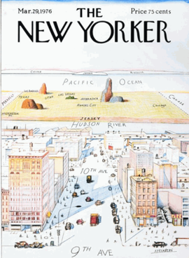
Consequently the recent availability of a plugin for generating cartograms in Quantum GIS meant that I just had to fiddle around with it. Although I like cartograms I like even more to see the detailed mapping distorted in the same way as the cartogram. There are many famous cartoons exploiting a distorted view of the world to make both humourous and serious points. (I recommend the excellent book called Mental Maps by Peter Gould and Rodney White for many other examples).

View of USA from 9th Avenue, a well-known New Yorker cover cartoon.
Source: Wikimedia.
As is traditional in this blog my starting point was locations of pubs. Pubs are distributed very unevenly being concentrated in the city centre and along major roads. They are therefore a fairly good way of enlarging the centre of a city in a cartogram. The other virtue is that there are not too many pubs: early experiments with the cartogram plugin showed that I had to be conservative in the data I used.

My first step was to create Voronoi polygons from the nodes representing the pubs. This is a simple operation available in Quantum GIS. In this way every part of the area under consideration was assigned to a single pub. by assigning an arbitrary area constant to each polygon and using this as the driver of the cartogram plugin it is very easy to produce a basic cartogram.

Nottingham_Pub_Voronoi
Voronoi polygons for pubs in central Nottingham.
The outline of the road network is shown to provide a little context.

However, my main goal was to distort ALL the underlying OpenStreetMap data in line with the cartogram distortion. To do this I overlaid a regular grid of squares 200 m on the side over the pub Voronoi polygons. These grid squares were then merged with the pub polygons so that each polygon was split into many smaller ones. An arbitrary area value was calculated for each (as a percentage of the original pub polygon) and scaled so no value was less than 1 (to avoid the plugin crashing). Once again a cartogram was produced, but this time a number of the vertices had known starting co-ordinates arranged in a regular fashion. Each smaller polygon was uniquely identified by a compound key made from the pub polygon and the original grid square.

Nottingham_Pub_Voronoi_with_Grid
Gridded Voronoi polygons as above, but with a 200m square grid added.
Nottingham_Pub_VoronoiGrid_as_Cartogram
The basic cartogram derived from the gridded Voronoi polygons above.
Shading indicates all polygons corresponding to an individual pub.
With the basic cartograms created I imported them into PostGIS and then found the co-ordinates of all the vertices both in the original input data and the cartogram data. I filtered out only those co-ordinates which were at the vertices of the original grid squares and calculated simple X and Y offsets for each of these points. The offsets could then be applied to all points in the standard node table of an Osmosis snapshot schema. (I added a very simple interpolation of X and Y co-ordinates within each grid square as well). In practice I carried out all operations in the British National Grid (EPSG: 27700) and then converted back to WGS84 at the final step.

Finally I extracted the (distorted) data from my snapshot schema and stored it in the OSM XML format. To render the modified data I used Maperitive which is pretty much perfect for this purpose. The final result is shown at the head of this blog entry.

I leave it as an exercise  for the reader to find any useful purpose for this process!

Wednesday, 9 March 2011

Former Pubs

Dover Castle : 1152c

An inevitable problem arises when mapping in Britain these days. How does one map dead pubs?

Pubs have been dying at an increasing tempo ever since the Beer Orders of 1989. Some of this is due to the rapacity of the 'pubcos', but much is due to cheap supermarket booze, social change in inner-city areas, and a broader range of alternative means of entertainment. Although dead pubs exist everywhere, it's the ones in inner-city areas, or suburban estates, which I notice most frequently.

Some pubs are 'zombies', having fallen into a 'close-reopen-fail-close' cycle (phrase nicked from Richard on IRC). These can often be identified by the 'run your own pub' banners outside. There are also pubs which are only slightly more alive: often remarkably difficult to work out their actual status when walking past during the day. Just occasionally one of this class of pub gets resurrected. I tend to tag all such pubs as ordinary pubs, but if currently closed will add "(closed)" after the name. I do this for two reasons: an amazing number do show a triumph of hope over experience, and re-open; and, secondly, pubs are important navigational landmarks. The Target roundabout at Northolt on the A40 is a good example of the latter, even though the pub closed in 1986 when it was converted to a burger bar.

Once the pub sign has gone and all the windows are boarded up then I'm willing to accordingly change the tagging to amenity=dead_pub or similar. Usually such pubs either change use, or get demolished. Local to Nottingham they've turned into supermarkets (two Tesco Express stores : the Jolly Higglers, 17/21st Lancers), Indian restaurants (The Poachers Tavern now the Gurkha Kitchen) and mosques (Le Grand, Hyson Green , and possibly The Boulevard). The A610, Nuthall Road, has a large number of recently demolished pubs, typically they are replaced by housing. Other recent housing developments include : Cremorne Drive is a private gated road in The Meadows on the site of the Cremorne Hotel; Beaumont Square has been built on the site of The Wollaton Arms.

Robin Hood, Pinkneys Green : 17402Elsewhere, the Stonor Arms in Stonor has been closed since the early 2000s, and despite recentish press coverage didn't look likely to open again last summer, but The Robin Hood in Pinkneys Green sprang into life again in 2007 after being boarded-up for 6 years. So its remarkably difficult to be certain about dead pubs.

A very few remain intact as buildings but with a changed use, like The Dover Castle (photo above), now let as student accommodation. I don't know when this closed, but it was already there by the time of the 1891 census. Familiarity with an area, or close inspection of the building will reveal the former use: then it's worth recording them as building=pub.

P.S. Chris Richards (riffdesign) has some nice atmospheric photos of Radford between '70s and early 90s, including several dead pubs.