Showing posts with label Public Footpath. Show all posts

Saturday, 10 January 2015

New Year footpath mapping with Mappa Mercia near the Fauld Crater

My first countryside excursion of 2014 was to investigate a man-made hole. For 2015 I choose a different bigger hole which I've meant to visit for a long time: the Fauld Crater. What was different this year is that we made it an OpenStreetMap mapping and social event!

OSM Mappers near Fauld Gypsum Works
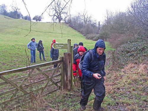
Mapping footpaths for OpenStreetMap near the Fauld Crater, East Staffordshire
I'd mentioned at our last pub meeting of the year that I fancied doing some footpath mapping between Christmas & the New Year. Coincidentally Rob Nickerson of Mappa Mercia asked if we were organising anything after Christmas. So the idea of 2 or 3 of us getting together grew to the notion of linking up with Mappa Mercia. So in the end the meeting had quite a diverse set of goals:
  • Do some mapping together
  • Walk and map unmapped footpaths
  • An excuse for a post-Christmas walk
  • Link up socially with Mappa Mercia
  • Initiate another type of OSM activity in the (East) Midlands

Monday, 14 April 2014

10 years of footpath mapping for OpenStreetMap

On a Saturday in late March I joined Nick Whitlegg, one of the earliest OpenStreetMap contributors, for a session mapping footpaths in the Weald. I was introduced to Nick several years ago on the basis that we were both walkers. But this was the first time we'd actually done a walk together, and my first opportunity to see how a real expert on footpath mapping did things.

Nickw with lots of footpath detail needing mapping
near Ockley, Surrey

Wednesday, 2 October 2013

OpenStreetMap at a Public Inquiry

Summary (tl;dr)

OpenStreetMap featured in a Public Inquiry about whether a particular route was a Public Right of Way (PRoW). I appeared as a witness at this Inquiry for Paul Sladen (another OSMer) regarding how it has been mapped on OSM. This post describes the unusual circumstances as to why the status of Lenton Road path is controversial, a bit about the history of the path, details of my statement and the hearing, and a little bit about other uses of OSM in official planning processes.

Gate at the Lenton end of Lenton Road.
The installation of this gate and later locking of the gate at night time
was one of the sources of disagreement about the status of the footpath.
Source: Mick Garratt on Geograph via Wikimedia Commons