In my post on Woodland Cartography I noted with regret that I had not consulted the Shorter Science and Civilisation in China regarding cartography.
I've now read the relevant chapter, and was rather disappointed. Although there was a fair amount of information about surveying, there was very little about cadastral surveys. Elsewhere in the world they seemed to be a major driver for collecting information about trees and woodland in the past. (Subsequently, I've also had a peek in the relevant complete volume of Science & Civilisation in China, and it suffers from the same deficiency).
What was interesting was a map from the 12th century which shows China with a rectangular grid overlay.
My interest was piqued, because I had not given over much thought to the historical development of gridded map systems: other than to assume most kilometric grids originated from military needs. In fact a recent discussion revealed that the Irish Grid was created around the time of the Second World War, with an antecedent in the grid used on the GSGS sheets of out-of-copyright maps shown on the Irish OSM server.
One early and prominent grid is the township grid of 6 by 6 mile squares which overlays much of the Western USA. This was created in the early days of the Republic, but like many such cadastral systems was more a series of grids with different origins than a single grid (see the wikipedia article for detail). I've made a crude attempt to map one such township in Oregon, close to the ranch founded by my great-great uncle.
Similarly in Ireland, the initial survey for the 6 inch maps produced sheets on county lines; as did the equivalent, but much later survey in Great Britain. Probably the same happened in other places: quite local grids initially, with consolidation occurring later.
Coincidentally Mike Dobson discusses location grids in a recent post about what3words. His discussion not only places their use in a modern context, but also has more information on their origins.
Thursday, 20 August 2015
Tuesday, 19 May 2015
Retail Outlets on OpenStreetMap: Cartograms, and Patchwork Quilts
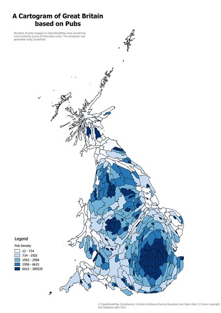
I enjoyed the process of creating a cartogram from OpenStreetMap data a couple of years back, even if it was somewhat tedious. However two things stopped me from taking it further: the QGIS plugin I was using does not work with later editions, and I really wanted something a little more refined.
![]() |
| Cartogram of Local Authority areas in Great Britain based on numbers of pubs on OpenStreetMap Created using ScapeToad, this is a simple, and naive, cartogram. |
Monday, 4 May 2015
Documenting Footpaths with Mapillary
I have long been a believer in the need to document OpenStreetMap survey data as thoroughly as possible.
I have a large archive of audio files, GPS traces, and tens of thousands of photographs. These span back to late 2008 when I started contributing to OSM. From time to time these prove useful, for instance, I had very precise documentation for my evidence at a Public Enquiry.
However, sharing such archival information with other mappers is difficult. It's not even straightforward for me to locate stuff. I have used OpenStreetView (OSV) since it was announced at SotM Girona. It is difficult to share photos using OSV, and the interface has not developed since 2010.
I was therefore very interested to learn about Mapillary, but was initially put off by the licensing. When they changed the licensing I was more interested. At SotM-EU Karlsruhe I was able to chat with Yubin after hearing his talk, which convinced me to give it a go. As I've said before, I regret I did not do this the following morning when full documentation of our walk at the Weingartnermoor would have been very useful, not just for mapping this particular place, but for discussing how to map woodland.
I don't have an Android phone which is compatible with Mapillary so I have had to do things manually. This is a little tedious, so I tend to keep the creation of sequences for things which are either simple or of particular value.
I have a large archive of audio files, GPS traces, and tens of thousands of photographs. These span back to late 2008 when I started contributing to OSM. From time to time these prove useful, for instance, I had very precise documentation for my evidence at a Public Enquiry.
However, sharing such archival information with other mappers is difficult. It's not even straightforward for me to locate stuff. I have used OpenStreetView (OSV) since it was announced at SotM Girona. It is difficult to share photos using OSV, and the interface has not developed since 2010.
I was therefore very interested to learn about Mapillary, but was initially put off by the licensing. When they changed the licensing I was more interested. At SotM-EU Karlsruhe I was able to chat with Yubin after hearing his talk, which convinced me to give it a go. As I've said before, I regret I did not do this the following morning when full documentation of our walk at the Weingartnermoor would have been very useful, not just for mapping this particular place, but for discussing how to map woodland.
I don't have an Android phone which is compatible with Mapillary so I have had to do things manually. This is a little tedious, so I tend to keep the creation of sequences for things which are either simple or of particular value.
Labels:
footpaths,
ground survey,
Mapillary,
OpenStreetMap,
survey data,
verification
Thursday, 30 April 2015
Interviewed by OpenCageData
I was recently interviewed by Ed Freyfogle of OpenCageData.
Ed asked some questions about this blog which I had to think about a bit. I'm not sure if I've explained myself very well, but, in case you missed it, the interview is here.
At some stage when I've cogitated on these answers even more I might expand them directly on the blog.
Ed asked some questions about this blog which I had to think about a bit. I'm not sure if I've explained myself very well, but, in case you missed it, the interview is here.
At some stage when I've cogitated on these answers even more I might expand them directly on the blog.
Labels:
interview,
Lokku,
OpenCageData,
OpenHistoricalMap,
OpenStreetMap
Tuesday, 31 March 2015
Bat Bridges, or why deleting lonely tags is a bad idea
The other day I was idly browsing the blog of Mark Avery, the former conservation director of the British bird protection society, the RSPB. One item caught my attention: it was about 'bat bridges'. Although I hadn't heard of them before it was pretty obvious what they might be.
Bats tend to follow linear features in the landscape when foraging at night, at least in part because they provide protection from predators. Bats tend to avoid flying over open spaces. Hedgerows, edges of woods, and so on, form commuting routes between roosting and feeding sites for bats. When these are damaged or destroyed, for instance by road building, bats either lose feeding locations or have to cross the open space. Usually they do this by flying low: effective against their age-old predators, but not much help when confronted by a car.
![]() |
| A bat bridge on the A590 in Cumbria |
Bats tend to follow linear features in the landscape when foraging at night, at least in part because they provide protection from predators. Bats tend to avoid flying over open spaces. Hedgerows, edges of woods, and so on, form commuting routes between roosting and feeding sites for bats. When these are damaged or destroyed, for instance by road building, bats either lose feeding locations or have to cross the open space. Usually they do this by flying low: effective against their age-old predators, but not much help when confronted by a car.
Saturday, 10 January 2015
New Year footpath mapping with Mappa Mercia near the Fauld Crater
My first countryside excursion of 2014 was to investigate a man-made hole. For 2015 I choose a different bigger hole which I've meant to
visit for a long time: the Fauld Crater. What was different this year is
that we made it an OpenStreetMap mapping and social event!
I'd mentioned at our last pub meeting of the year that I fancied doing some footpath mapping between Christmas & the New Year. Coincidentally Rob Nickerson of Mappa Mercia
asked if we were organising anything after Christmas. So the idea of 2
or 3 of us getting together grew to the notion of linking up with Mappa
Mercia. So in the end the meeting had quite a diverse set of
goals:
![]() |
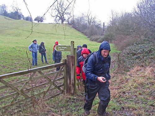
| Mapping footpaths for OpenStreetMap near the Fauld Crater, East Staffordshire |
- Do some mapping together
- Walk and map unmapped footpaths
- An excuse for a post-Christmas walk
- Link up socially with Mappa Mercia
- Initiate another type of OSM activity in the (East) Midlands
Wednesday, 31 December 2014
Finding ones way around Buenos Aires in 1870: a proof-of-concept for routing with OpenHistoricalMap data
A critical point about using OpenStreetMap technologies in OpenHistoricalMap is that we should get lots of useful tools for free.
We touched on this point during our end-of-year Google Hangout. In particular Karl Grossner. wanted to know more about how one might use the data for routing. Karl is part of the team behind the awesome ORBIS project at Stanford, which allows routing across Europe during the Roman Empire.
| Plaza de Mayo 25, Buenos Aires in the 1860s Source: Wikimedia Commons CC-BY-SA |
We touched on this point during our end-of-year Google Hangout. In particular Karl Grossner. wanted to know more about how one might use the data for routing. Karl is part of the team behind the awesome ORBIS project at Stanford, which allows routing across Europe during the Roman Empire.
Subscribe to:
Posts (Atom)