Sunday, 25 October 2015

Urban Areas: a meditation on why simple global geographical datasets are so poor

Puerto-Vallarta
Puerto Vallarta, an aerial view of an urban area missing many roads on OpenStreetMap.
The area in the middle distance away from the sea was particularly lacking.
Fortunately the centre of the hurricane didn't pass over this area.
Source: Wikimedia Commons, (c) CC-BY-SA


The other night, as Hurricane 'Patricia' bore down on the Pacific coast of Mexico, I had a twitter conversation with Bill Morris and others regarding how well mapped Puerto Vallarta was on OpenStreetMap. (BTW: I'm sure it's much better mapped now).
Of course, OSM is about fixing things, so I carried out the conversation in between adding around a hundred streets to the city. However the really interesting question was this one:

Whilst at breakfast I thought a little more about this. I decided it ought to be possible to do something fairly simple with data which already exists.

Friday, 16 October 2015

Irish Vice Counties : the creation of a specific dataset on OpenStreetMap

I've been meaning to write about OpenStreetMap Ireland's townland mapping project for some time.

It's a wonderful example of how historical maps are of significant value in creating really useful data on OpenStreetMap which is just as relevant as it today as was in the past.

The immediate reason for writing about them is that I have been creating vice county boundaries for Ireland. In doing so I have not just been using the data, but the fantastic range of resources made available through the activities of the townlands project.

Irish vice counties ex osm multicolour
The Vice Counties of Ireland
My first complete draft of the boundaries on OpenStreetMap

Wednesday, 16 September 2015

Plantations : woods, forests or something else?

Stand of trees at New Fen - geograph.org.uk - 636879
Poplars at Lakenheath
CC-BY-SA 2.0   © Copyright Alison Rawson and licensed for reuse under this Creative Commons Licence.
One type of woodland area I have alluded to a couple of times in the past are plantations (see here and here). I've always been frustrated at not having found good illustrations, but in the past couple of weeks I've noted a few which either already have good open images available or I've been able to snap a picture myself.

Plantations run the gamut from small areas to fully-fledged forests. In general what connects them is that the trees are planted in orderly rows, and the plantation has an expected lifetime, after which the trees will be harvested or replanted. Photographs enable some of the variety to be shown. In turn this should highlight the sorts of information we might want to capture by OpenStreetMap tags.

Thursday, 10 September 2015

Why does The Guardian think that OpenStreetMap is owned by Google

My attention was drawn by a tweet to an article in The Guardian online showing some nice examples of cartography:

To my amazement it contained this:


To quote "Google's OpenStreetMap"!

Now, The Guardian has generally covered OpenStreetMap well over the years, and has made use of appropriately credited OSM data from time-to-time over the years. Last year it re-published Serge Wroclawski's influential blog post "Why the world needs OpenStreetMap". It's former Technology editor, Charles Arthur, was very familiar with OpenStreetMap, and in turn played a big part in the campaign to get open data from the Ordnance Survey.

This error is symptomatic of two things:
  • A widespread assumption that anything to do with on-line maps must come from Google (most often seen in the belief that the images are taken with Google's own statellites).
  • An absence of care in fact-checking when taking information from other webpages. 
There is not a great deal that the OpenStreetMap community can do about the former. After all commercial players such as DigitalGlobe have to put up with the same sort of thing. However, we can do something about the latter: but in general probably don't put enough effort into such things. (Perhaps unsurprising, its more fun to survey & add data than try and get people to get their facts right).

A quick google search reveals more or less the identical string in numerous webpages referring to Luis Dilger's 3-D city visualisations:

Clearly most of these are just straight copying from a single source. However it is not the original statement by Dilger (see link above). So it looks like The Guardian really has not checked it's facts and has the text is probably unoriginal too.

Thankfully I got a speedy response from them (thanks to twitter):


All-in-all the episode highlights that as a group we in OpenStreetMap have a long way to go in communicating who we are and what we do to mainstream media types.

Wednesday, 9 September 2015

Shops in Coalville


I had not planned to do much mapping on the Bank Holiday Sunday: the day was set aside for a meeting of the British Plant Gall Society at Ryton Woods, Warwickshire.

Oak with Hazel coppice stools, Ryton Wood.
The ground layer changes here with bramble (in foreground) absent deeper into the wood.
Just to the left of the foreground hazel a bank & ditch can just be discerned. This is probably the remnants of a woodland compartment dating back to the Middle Ages.

The only thing I expected to map were paths in the wood, which surprisingly are almost all unmapped (hint to Mappa Mercia folks). This is one of the best areas of ancient woodland in the county and only a short distance from Coventry and Warwick. In fact, if anything, I would have expected to write about this wood which is mainly Oak with Hazel coppice.

Coalville, Hotel Street geograph-3151694-by-Ben-Brooksbank
Coalville : Hotel Street in 1988.
The Railway Hotel is now a day nursery, and the buildings on the left beyond have recently been demolished.
The Railway was one of a cluster of pubs adjacent to the level crossing and station: the others continue as pubs.
Source Ben Brookshank, Geograph via Wikimedia Commons

Thursday, 20 August 2015

An Early Map Grid

In my post on Woodland Cartography I noted with regret that I had not consulted the Shorter Science and Civilisation in China regarding cartography.

I've now read the relevant chapter, and was rather disappointed. Although there was a fair amount of information about surveying, there was very little about cadastral surveys. Elsewhere in the world they seemed to be a major driver for collecting information about trees and woodland in the past. (Subsequently, I've also had a peek in the relevant complete volume of Science & Civilisation in China, and it suffers from the same deficiency).

What was interesting was a map from the 12th century which shows China with a rectangular grid overlay.

Yuji tu - enhanced contrast
The Yǔjī tú (禹迹图 following the footsteps of Yu).
A detailed map of China carved in the Song dynasty on a stele now in the Stele Forest Museum, Xi'an. The original image in the Library of Congress is a scan of a rubbing of the stele. This version has been converted to monochrome, inverted and normalized to enhance contrast.

My interest was piqued, because I had not given over much thought to the historical development of gridded map systems: other than to assume most kilometric grids originated from military needs. In fact a recent discussion revealed that the Irish Grid was created around the time of the Second World War, with an antecedent in the grid used on the GSGS sheets of out-of-copyright maps shown on the Irish OSM server.

One early and prominent grid is the township grid of 6 by 6 mile squares which overlays much of the Western USA. This was created in the early days of the Republic, but like many such cadastral systems was more a series of grids with different origins than a single grid (see the wikipedia article for detail). I've made a crude attempt to map one such township in Oregon, close to the ranch founded by my great-great uncle.

Similarly in Ireland, the initial survey for the 6 inch maps produced sheets on county lines; as did the equivalent, but much later survey in Great Britain. Probably the same happened in other places: quite local grids initially, with consolidation occurring later.

Coincidentally Mike Dobson discusses location grids in a recent post about what3words. His discussion not only places their use in a modern context, but also has more information on their origins.

Tuesday, 19 May 2015

Retail Outlets on OpenStreetMap: Cartograms, and Patchwork Quilts

I enjoyed the process of creating a cartogram from OpenStreetMap data a couple of years back, even if it was somewhat tedious. However two things stopped me from taking it further: the QGIS plugin I was using does not work with later editions, and I really wanted something a little more refined.

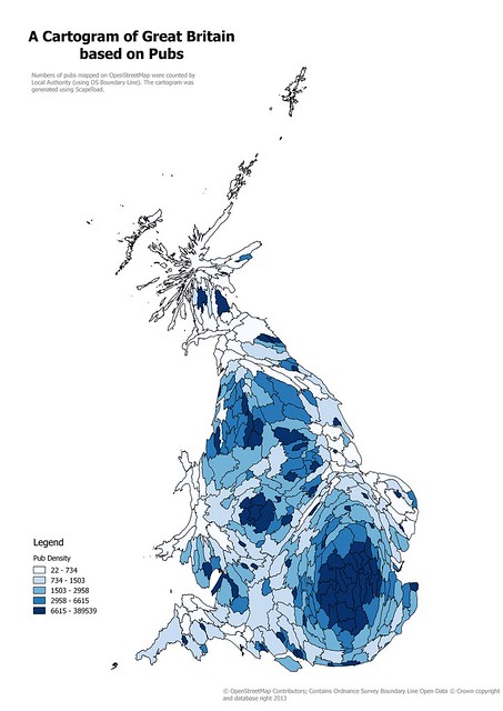
Pub Cartogram
Cartogram of Local Authority areas in Great Britain based on numbers of pubs on OpenStreetMap
Created using ScapeToad, this is a simple, and naive, cartogram.